
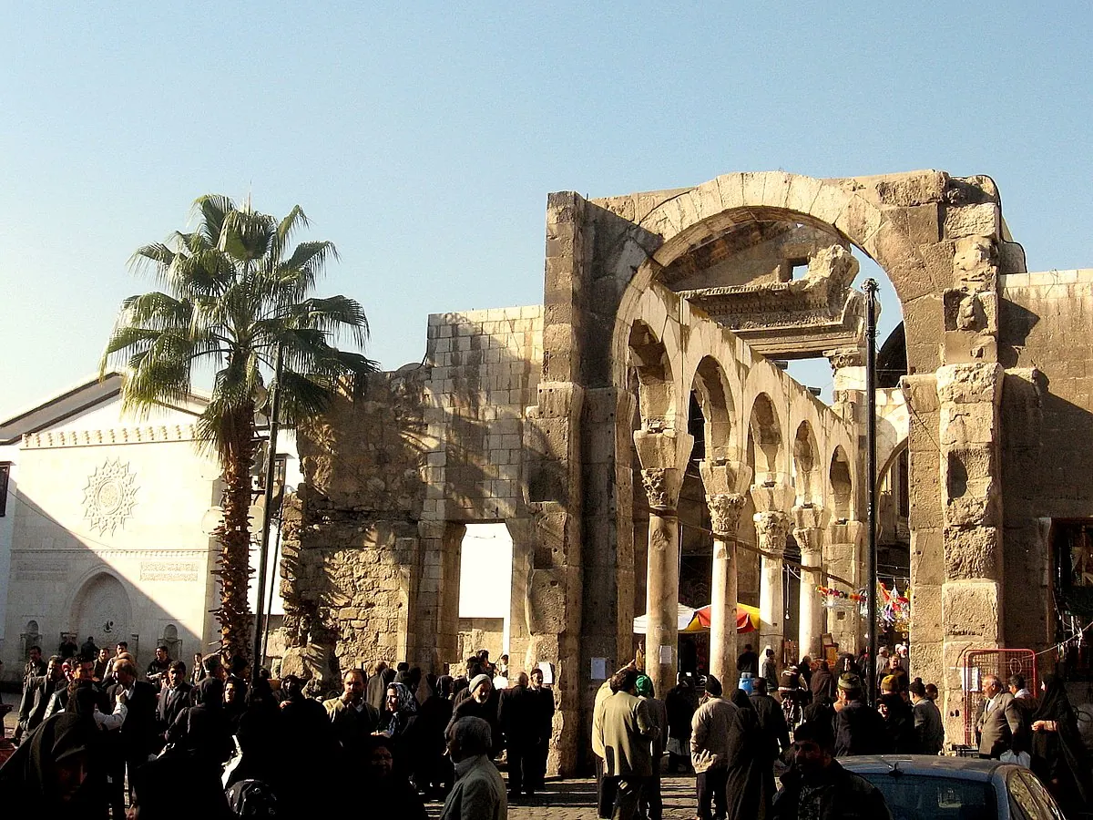
The Temple of Jupiter in Damascus · Photo: Ai@ce · CC BY 2.0 · Wikimedia Commons · Recorded 2008
Temple of Jupiter, Damascus
Local name: معبد جوبيتر الدمشقي
The Temple of Jupiter in Damascus was the Roman sanctuary of Jupiter in the north of today's old city, developed from earlier sanctuaries of Hadad and Zeus. In late antiquity it became a church of John the Baptist, and in the 8th century the Umayyad Mosque was built within its inner enclosure. Remains of gateways, colonnades and walls survive in the old city.
History
In the Iron Age Damascus was the capital of the Aramaean state of Aram-Damascus, whose people worshipped the storm god Hadad-Ramman. According to the English and Arabic Wikipedia his temple stood on the site of the present Umayyad Mosque; the German Wikipedia considers both its appearance and its location unknown. One stone survives: a block with an Egyptian-style sphinx reused in the mosque (German Wikipedia), or a stone of King Hazael's reign now in the National Museum of Damascus (English and Arabic Wikipedia). In the Seleucid period Hadad was identified with Zeus; under Antiochus IV, the English Wikipedia says, the sanctuary was redeveloped as a temple of Zeus.
After the Roman conquest in 64 BCE the cult was transferred to Jupiter. A building inscription of Augustus dates the start of the expansion; the inner court (temenos) was completed soon after 14 CE and the outer court (peribolos) by the middle of the 1st century. The temple was refurbished under Septimius Severus (193–211). The scholar Maamoun Abdulkarim attributes the design to the Damascus-born architect Apollodorus. An inscription attests a visit by Emperor Julian (361–363).
During the persecution of pagans Theodosius I converted the temple into a church of John the Baptist; the German Wikipedia speaks of demolition and the conversion of parts. After the Muslim conquest (German Wikipedia: 634; English and Arabic: 635) the church remained in use for some time; Caliph al-Walid I ordered the Umayyad Mosque in 706, built into the south side of the old temenos.[1][2][3]
Architecture
The complex consisted of two walled enclosures: an outer peribolos, which also held a market, and the inner temenos with the cella and cult image at its centre. Towers stood at the four corners of the temenos for rituals in the Semitic tradition. The main entrance was on the east, approached by a colonnaded street from the agora. The German Wikipedia gives 380 by 310 metres for the peribolos and 56 by 97 metres for the inner court; Wulzinger and Watzinger measured the peribolos in 1921 at about 350 by 450 metres. By the 4th century it was the largest temple in Roman Syria.[1][2][3]
Research
Richard Pococke published a plan of the compound in 1745, and Josias Porter in 1855 a plan showing 40 columns or column fragments surviving between the houses. According to the Arabic Wikipedia, remains of the temple have been uncovered since 2006 in front of the mosque's southern gate. UNESCO names the extensive remains of the Temple of Jupiter among the earliest visible Roman evidence in the World Heritage property Ancient City of Damascus.[1][3][4]
Timeline
- 64 BCE
- c. 14 CE
Temenos completed soon after the end of Augustus' reign.[1][3]
- 193–211
- 706
Al-Walid I orders the construction of the Umayyad Mosque.[2]
- 1745
- 1921
Plan by Wulzinger and Watzinger (peribolos c. 350 × 450 m).[1][3]
- from 2006
Temple remains uncovered in front of the mosque's southern gate (per Arabic Wikipedia).[3]
Gallery
Documented condition
Current condition not documented · as of 2026
Parts of the temenos walls now form outer walls of the mosque. Remains of three entrances of the outer enclosure survive, among them the western gate between Suq al-Hamidiyya and the mosque, with well-preserved parts of a colonnade; to the east the axis continues into the al-Qaymariyya quarter. Further fragments are scattered through the surrounding houses, shops and khans. No dated condition report exists.[1][2][3]
Visiting
Getting here
Documented ride, stay and transport services in Damascus:
Nearby medical services
Straight-line distance from this place. Data: OpenStreetMap, as of 2026-10-30. Operating status not verified – call before going.
- مشفى الغزاليHospital · 0.9 kmDirections
- Al kendy HospitalHospital · 1 kmCallDirections
- مشفى العين والاذنHospital · 1 kmDirections
- HospitalHospital · 1.1 kmDirections
- مشفى الطب الجراحيHospital · 1.1 kmDirections
- المشفى السوري التخصصي لأمراض جهاز الهضمHospital · 1.1 kmDirections
Sources (11)
- Wikipedia (en): Temple of Jupiter, Damascus rev. 1364720939 · CC BY-SA 4.0 · 2026-10-30
- Wikipedia (de): Jupitertempel in Damaskus rev. 270496236 · CC BY-SA 4.0 · 2026-10-30
- Wikipedia (ar): معبد جوبيتر الدمشقي rev. 71908625 · CC BY-SA 4.0 · 2026-10-30
- UNESCO World Heritage Centre: Ancient City of Damascus · 2026-10-30
- Wikidata · CC0 · 2026-10-30
- Wikipedia (es) · CC BY-SA 4.0 · 2026-10-30
- Wikipedia (hi) · CC BY-SA 4.0 · 2026-10-30
- Wikipedia (it) · CC BY-SA 4.0 · 2026-10-30
- Wikipedia (pt) · CC BY-SA 4.0 · 2026-10-30
- Wikipedia (ur) · CC BY-SA 4.0 · 2026-10-30
- OpenStreetMap · ODbL · 2026-10-30
Widersprüche: (1) Aramäischer Tempel – en/ar am Ort der Moschee, de Lage unbekannt. (2) Erhaltener Stein – en/ar: Stein aus der Zeit Hasaels im Nationalmuseum Damaskus; de: Sphinx-Block in der Moschee wiederverwendet; ob identisch, unklar. (3) Maße – de Peribolos 380 × 310 m, Innenhof 56 × 97 m; en/ar nach Wulzinger/Watzinger 1921 ca. 350 × 450 m. (4) Eroberung – de 634, en/ar 635. (5) Theodosius I. – en Umwandlung, de Abriss und Umbau von Teilen. (6) Bauzeit – en/ar 'bis Constantius II.', ohne Belegdetail, nicht übernommen. (7) Apollodor – en als Zuschreibung durch Abdulkarim, ar als Tatsache; als Zuschreibung wiedergegeben. Angaben zu Kosten/Arbeitern des Moscheebaus (de, nach Ibn al-Faqih) betreffen die Moschee und wurden nicht übernommen. Umwandlung unter Theodosius I. ohne Jahresangabe im Paket, daher nicht in der Timeline. Q183562 aus bestehendem Redaktionsdatensatz; Q3678596 nach Wikidata P361.