
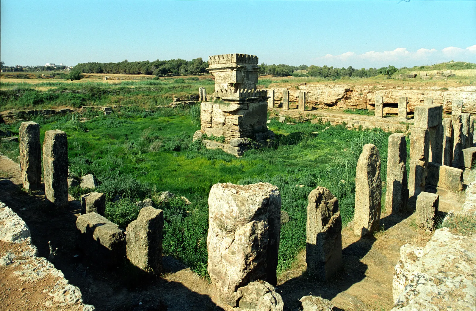
Syria, Amrit · Photo: Jerzy Strzelecki · CC BY-SA 3.0 · Wikimedia Commons
Amrit
Local name: عمريت
Amrit, ancient Marathus (Greek Marathos), was a Phoenician city on the Mediterranean coast about six kilometres south of Tartus, between the mouths of the Nahr Amrit and the Nahr al-Qubli. It mostly belonged to the mainland territory of the island city of Arwad. Its remains, spread over about 7.5 km², include a rock-cut temple sanctuary, a stadium and a necropolis with tomb towers; a small modern village of the same name lies at the site.
History
Ceramics show occupation as early as the 3rd millennium BC; German Wikipedia dates the earliest traces at Tell Amrit to about 2100–1750 BC and describes a foundation of the town by Amorites from Arwad around 1600 BC. A place mentioned in records of the wars of Thutmose III is today usually identified with Amrit. At the end of 333 BC Alexander the Great stayed at Marathus, then a mainland possession of King Gerostratus of Arados (Arwad).
In the Seleucid period Marathus broke away from Arados; it minted its own coins around 230 BC, and by 219 BC the two cities were separate. According to English Wikipedia, Marathus was sacked by forces from Arados in 148 BC; German Wikipedia, following Diodorus, reports a failed Aradian attempt before 147 BC and considers the exact date of destruction unknown. Strabo described the place as a city torn down. Roman authors still mentioned Marathus up to Hadrian's time, and three Roman-period tomb chambers were found in 2011.
Henry Maundrell (1697) and Richard Pococke (1743) visited the ruins; Ernest Renan excavated in 1860, Maurice Dunand in several campaigns from 1926, and with Nassib Saliby from 1954. Finds are held in the Louvre, the National Museum of Damascus and the Tartus Museum, among others.[1][2]
Site
The main sanctuary (Maabed), probably of the second half of the 5th century BC according to German Wikipedia, is cut from the rock: a pillared portico surrounds a basin about three metres deep fed by a spring, with a cube-shaped naiskos on a tall base at its centre. Dimensions differ between sources (English Wikipedia: court 47 × 49 m; German Wikipedia: complex 56.33 × 48.55 m, basin 46.70 × 38.50 m). Inscriptions attest the worship of Melqart and Eshmun.
About 200 metres to the northeast lies a rock-cut stadium some 225–230 metres long and 30–40 metres wide with seven partly preserved rows of seats, dated to the late 4th or early 3rd century BC. To the south stand the tomb towers known as al-Maghazil (“the Spindles”), up to about 7.5 metres high, one decorated with four lion protomes, above underground chambers with finds from the 5th to the 1st century BC; south of the Nahr al-Qubli are the Burj al-Bazzaq, originally 19.5 metres high, and further hypogea.[1][2][3]
Historical use and significance
English Wikipedia describes Marathus as the northernmost important city of ancient Phoenicia and Arwad's continental base. According to Arabic Wikipedia, the spring sanctuary was also visited for healing; the stadium is thought to have hosted sacred games. The city struck bilingual silver coins on the Attic standard. Because the site was largely abandoned and little rebuilt, its ruins survive without extensive later remodelling.[1][2][3]
Timeline
- c. 1600 BC
Town founded by Amorites from Arwad according to German Wikipedia; traces of settlement go back to the 3rd millennium BC.[1][2]
- 333 BC
Alexander the Great at Marathus; submission together with Arwad.[1][2]
- 219 BC
- c. 148 BC
Sacked by Arados (English Wikipedia); German Wikipedia considers the date of destruction unknown.[1][2]
- 1860
- 1954
Excavations by Maurice Dunand and Nassib Saliby; the temple is cleared by 1957.[1][2]
- 2004/2006
Included on the World Monuments Fund watch lists.[1]
Gallery
Documented condition
Current condition not documented · as of 2006
The World Monuments Fund placed Amrit on its 2004 and 2006 watch lists of endangered sites, citing rapid deterioration from vandalism and encroaching development. In 2006 a three-day workshop was held with UNESCO, the Syrian Directorate-General of Antiquities and Museums and local administrators. The sources contain no later condition report.[1]
Visiting
Getting here
Documented ride, stay and transport services in Tartus:
Nearby medical services
Straight-line distance from this place. Data: OpenStreetMap, as of 2026-10-30. Operating status not verified – call before going.
- Tartous National HospitalHospital · 4 kmDirections
- مشفى الكنديHospital · 4.9 kmDirections
- Al Kindy HospitalHospital · 5 kmDirections
- Dr. Youssef Al Hussein Fertility CenterHospital · 5.1 kmCallDirections
- مركز الكورنيش الاسعافيHospital · 5.5 kmDirections
- مستشفى الرازيHospital · 5.8 kmDirections
Sources (13)
- Wikipedia (en): Amrit rev. 1374854282 · CC BY-SA 4.0 · 2026-10-30
- Wikipedia (de): Amrit rev. 271740374 · CC BY-SA 4.0 · 2026-10-30
- Wikipedia (ar): عمريت rev. 72686503 · CC BY-SA 4.0 · 2026-10-30
- Wikidata · CC0 · 2026-10-30
- Wikipedia (es) · CC BY-SA 4.0 · 2026-10-30
- Wikipedia (fa) · CC BY-SA 4.0 · 2026-10-30
- Wikipedia (fr) · CC BY-SA 4.0 · 2026-10-30
- Wikipedia (it) · CC BY-SA 4.0 · 2026-10-30
- Wikipedia (nl) · CC BY-SA 4.0 · 2026-10-30
- Wikipedia (pl) · CC BY-SA 4.0 · 2026-10-30
- Wikipedia (sv) · CC BY-SA 4.0 · 2026-10-30
- Wikipedia (ur) · CC BY-SA 4.0 · 2026-10-30
- OpenStreetMap · ODbL · 2026-10-30
Kein UNESCO-Eintrag im Paket. Konflikte: Gründung im 3. Jt. v. Chr. (en, ar) vs. erste Spuren 2100–1750 v. Chr. und Stadtgründung um 1600 v. Chr. (de); Ende der Stadt: Plünderung 148 v. Chr. (en, Wikidata P576) vs. gescheiterter Angriff vor 147 v. Chr., Zerstörungsdatum unbekannt (de); Tempelmaße 47 × 49 m (en) vs. 56,33 × 48,55 m bzw. Becken 46,70 × 38,50 m (de); Stadion spätes 4./frühes 3. Jh. v. Chr. (en) vs. frühhellenistisch/4. Jh. (de); Entfernung zu Tartus 6 km (en, de) vs. 7 km (ar). Nicht übernommen: ar-Behauptungen, das Stadion sei die älteste Sportstätte der Welt und Ursprung des Wortes „Marathon“, sowie die Zuschauerzahl 11.200 und ein „Museum Amrit“. Zustandsangaben nur bis 2006 (WMF über en-Wikipedia); Status daher „unknown“.