
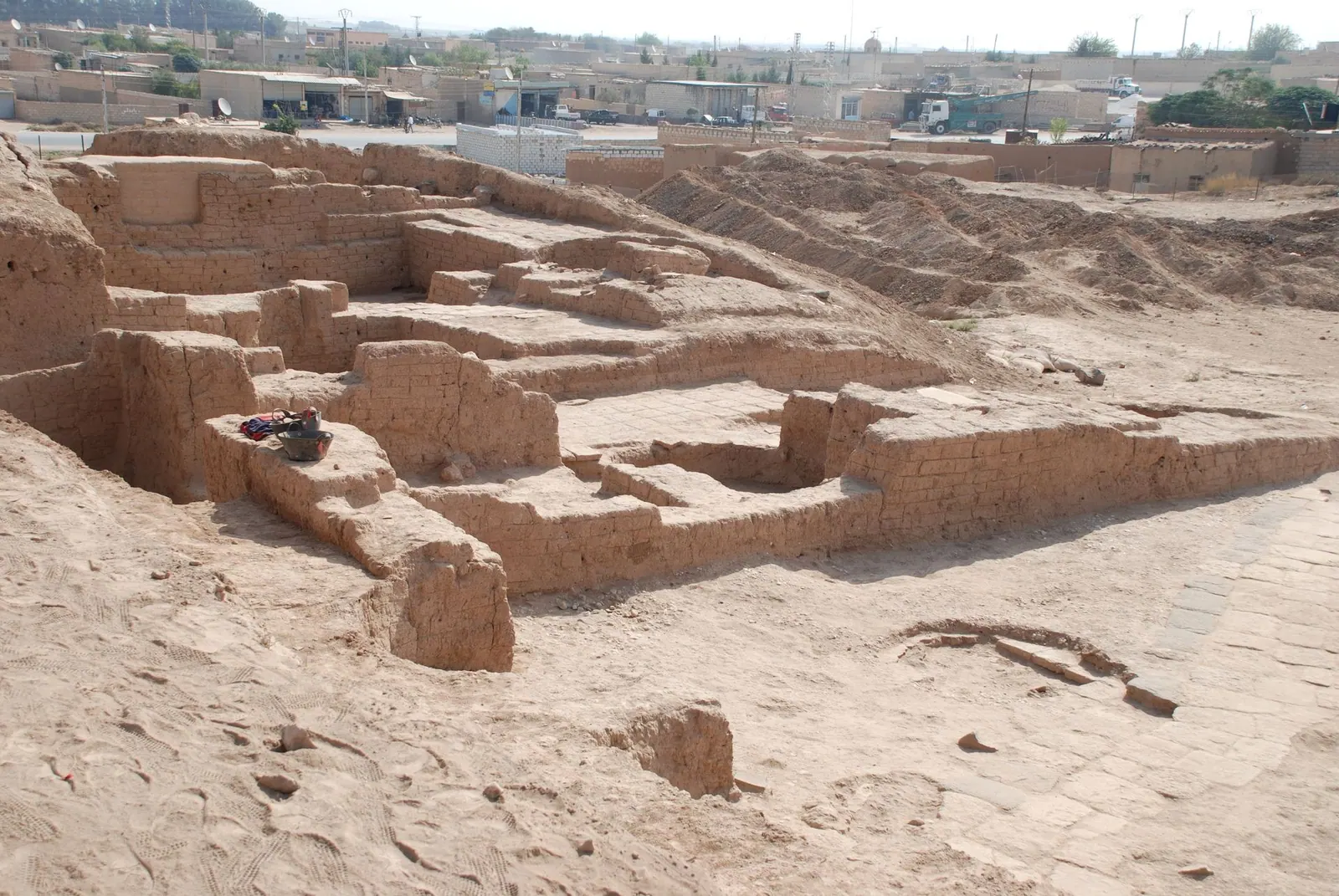
Tell Halaf, Syria, north-east palace · Photo: Bertramz · CC BY 3.0 · Wikimedia Commons · Recorded 2009
Tell Halaf
Local name: تل حلف
Tell Halaf is a settlement mound in north-eastern Syria on the Khabur river, about three kilometres west of Ras al-Ayn near the Turkish border. It is the type site of the Neolithic Halaf culture, and in the 1st millennium BCE it was the seat of the Aramaean and later Assyrian city of Guzana (Gozan).
History
The site was settled in the late Neolithic and gave its name to the Halaf culture, whose pottery is painted with polychrome geometric and animal designs. The English Wikipedia dates its floruit to about 6100–5400 BCE, the German Wikipedia the Halaf period to about 6000–5300 BCE. The Ubaid culture followed, and the site was then abandoned for a long time.
In the 10th century BCE (10th or 9th century according to the German Wikipedia) the rulers of the Aramaean kingdom of Bit Bahiani made the site, as Guzana, their seat; King Kapara built a richly sculpted palace on the citadel (the Western Palace, a hilani). The Assyrian king Adad-nirari II received tribute from Gozan; the English Wikipedia gives 894 BCE. In 808 BCE the city became a province of the Assyrian Empire, and the governors resided in the North-Eastern Palace. After the fall of Assyria it became a Babylonian colony in 612 BCE and remained inhabited until the Islamic period according to the German Wikipedia, until the Roman-Parthian period according to the English one. The Bible names Gozan as a destination of deported Israelites.[1][2][3]
Site
A bastioned citadel wall enclosed an upper town of 5.1 hectares, and an outer wall a lower town of about 50 hectares. The Western Palace stood on a high terrace; at its entrance, figure columns of the weather god and his family, standing on a bull and lions, carried the architrave, and the base of the walls was lined with basalt orthostats. According to the German Wikipedia their good state of preservation may be linked to a fire during the revolt of 759 BCE. A cult room, tombs and, in the lower town, an Assyrian-style temple were also uncovered.[1][2][3]
Research and collection history
Max von Oppenheim discovered the site in November 1899 and excavated from 1911 to 1913 and from 1927 to 1929. When the finds were divided, part of the sculpture went to Aleppo, forming the core of today's National Museum, and part to Berlin. There Oppenheim opened his own Tell Halaf Museum in 1930; it burnt out in an air raid in November 1943, and the basalt figures shattered into around 27,000 fragments. Between 2001 and 2010 (German Wikipedia: 2002–2009) more than 30 sculptures were reassembled and shown at the Pergamon Museum in 2011 and the Bundeskunsthalle Bonn in 2014. Since 2006 a Syro-German team has resumed excavations at the mound.[1][2][3]
Timeline
- c. 6100–5400 BCE
Floruit of the Halaf culture at the site (German Wikipedia: c. 6000–5300 BCE).[1][2][3]
- 10th/9th c. BCE
Guzana becomes the seat of Bit Bahiani; King Kapara builds the Western Palace.[1][2][3]
- 808 BCE
- 1899
- 1911–1913, 1927–1929
Oppenheim's excavations; finds divided between Aleppo and Berlin.[1][2][3]
- November 1943
Tell Halaf Museum in Berlin destroyed in an air raid.[1][2][3]
- 2006
- 2011
Restored sculptures exhibited at the Pergamon Museum, Berlin.[1][2]
Gallery
Documented condition
Current condition not documented · as of 2026
According to the German Wikipedia, village housing has extended up to the mound since the 1980s, so the area of the southern lower town can no longer be explored, and an Islamic cemetery still in use restricts excavation on the mound itself. The Arabic Wikipedia gives about 10,000 inhabitants for the surrounding village of Tell Halaf. No more recent condition report on the site is available.[2][3]
Visiting
Getting here
Documented ride, stay and transport services in Hasakah:
Nearby medical services
Straight-line distance from this place. Data: OpenStreetMap, as of 2026-10-30. Operating status not verified – call before going.
- Ras al-Ayn HospitalHospital · 3.8 kmDirections
- Rasulayn hospitalHospital · 3.8 kmDirections
Sources (18)
- Wikipedia (en): Tell Halaf rev. 1364720392 · CC BY-SA 4.0 · 2026-10-30
- Wikipedia (de): Tell Halaf rev. 270712745 · CC BY-SA 4.0 · 2026-10-30
- Wikipedia (ar): تل حلف rev. 76479119 · CC BY-SA 4.0 · 2026-10-30
- Wikipedia (en): National Museum of Damascus rev. 1382051165 · CC BY-SA 4.0 · 2026-10-30
- Wikidata · CC0 · 2026-10-30
- Wikipedia (es) · CC BY-SA 4.0 · 2026-10-30
- Wikipedia (fa) · CC BY-SA 4.0 · 2026-10-30
- Wikipedia (fr) · CC BY-SA 4.0 · 2026-10-30
- Wikipedia (it) · CC BY-SA 4.0 · 2026-10-30
- Wikipedia (ja) · CC BY-SA 4.0 · 2026-10-30
- Wikipedia (nl) · CC BY-SA 4.0 · 2026-10-30
- Wikipedia (pl) · CC BY-SA 4.0 · 2026-10-30
- Wikipedia (ru) · CC BY-SA 4.0 · 2026-10-30
- Wikipedia (sv) · CC BY-SA 4.0 · 2026-10-30
- Wikipedia (tr) · CC BY-SA 4.0 · 2026-10-30
- Wikipedia (ur) · CC BY-SA 4.0 · 2026-10-30
- Wikipedia (zh) · CC BY-SA 4.0 · 2026-10-30
- OpenStreetMap · ODbL · 2026-10-30
Widersprüche: (1) Halaf-Zeit – en/ar 6100–5400, de 6000–5300 v. Chr. (Wikidata 6100/5400). (2) Kapara – en 10. Jh., de 10. oder 9. Jh. (Synchronismen fehlen). (3) Adad-Nirari II. – en 894 v. Chr., de nur Regierungszeit 911–891. (4) Besiedlungsende – en römisch-parthisch, de/ar bis islamische Zeit. (5) Grabungsteam 1911 – en fünf Archäologen und 500 Einheimische, de fünf Architekten und 200 Arbeiter; Zahlen nicht übernommen. (6) Rekonstruktion – en 2001–2010, de 2002–2009. (7) Fundteilung – en ca. 80 Stücke (zwei Drittel) nach Berlin, 35 nach Aleppo; nicht übernommen. Lage: en 'wenige Kilometer', de 3 km westlich von Raʾs al-ʿAin. Kein UNESCO-Bezug im Paket. Relation findsHeldBy Q617254 nach dem Quellenpaket des Nationalmuseums Damaskus (en-Wikipedia: Skulpturen vom Tell Halaf); Nationalmuseum Aleppo und Pergamonmuseum ohne Q-ID im Paket. Wikidata P131 = Q233914 ohne Label – keine Relation gesetzt. Kein Bericht über Kriegsfolgen am Fundort im Paket.