
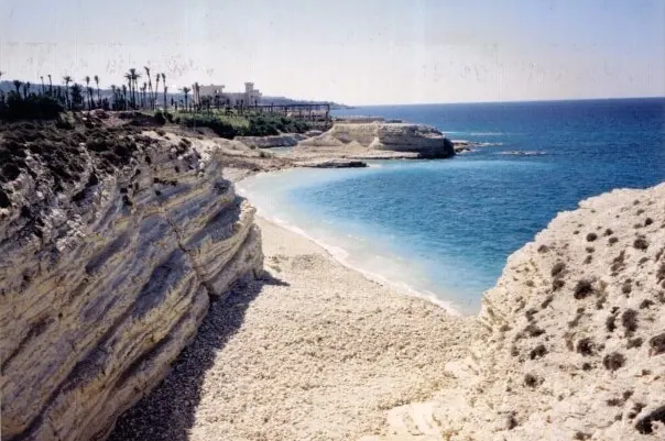
Burj Islam, a well-known beach just north of Latakia, named after a nearby village · Photo: Ahmadac ( talk ) / Ahmadac at en.wikipedia · Public domain · Wikimedia Commons · Recorded 2008
Syrian coast
Local name: الساحل السوري
The Syrian coast is the Mediterranean strip in north-western Syria comprising Latakia Governorate in the north and Tartus Governorate in the south. According to Arabic Wikipedia it runs from Tartus Governorate to Ras al-Basit and combines beaches, forested mountains and many ancient and medieval sites.
Landscape
Arabic Wikipedia gives the length of the coast as 180 km, but in the same sentence also mentions “about 35 nautical miles (65 km)”. Behind the shore lie forests, green mountains, springs, streams and rivers, and natural lakes as well as reservoirs behind dams. Several small uninhabited islands lie offshore, among them Bird Island, Umm al-Naml and Abbas Island, as well as the inhabited island of Arwad, about three nautical miles off Tartus.
Upland towns include Slinfah, about 50 km east of Latakia at around 1,200 m, and Kessab, about 65 km north of Latakia at around 800 m near Jebel Aqra. Ras al-Basit, about 40 km north of Latakia, is a wide bay surrounded by mountains and forest.[1][2]
History
According to Arabic Wikipedia, the term historically covered a much longer stretch of coast from Rafah to Mersin; the source attributes the present extent, limited to Latakia and Tartus, to the borders drawn after the First World War.
Latakia was founded by Seleucus I and named after his mother Laodice; surviving monuments include a Roman gateway from the time of Septimius Severus with four columns and an arch, and the Ottoman Khan al-Dukhan, now a museum. Tartus takes its name from Antaradus; the island of Arwad (Arados) off its shore was a Phoenician maritime kingdom. Jableh, 29 km south of Latakia, has a Roman theatre for about 7,000 spectators and the Sultan Ibrahim ibn Adham Mosque. Saladin's Castle, 35 km east of Latakia at 410 m, was regarded as one of the strongest fortresses of the Crusader period.[1]
Significance
Latakia is Syria's main Mediterranean port and Tartus another major port; Baniyas has an oil terminal and a refinery. Further archaeological sites named by the source include Ugarit, Amrit (Marathus), Marqab Castle and Tell Kazel (Simyra). The al-Mahabba festival is held in Latakia every year from 2 to 12 August.[1]
Gallery
Documented condition
Current condition not documented
Visiting
Getting here
Documented ride, stay and transport services in Latakia:
Nearby medical services
Straight-line distance from this place. Data: OpenStreetMap, as of 2026-10-30. Operating status not verified – call before going.
- مشفى الياسمين الاسعافيHospital · 8.6 kmDirections
- Baniyas National HospitalHospital · 14 kmDirections
- مشفى القدموس الوطنيHospital · 15 kmDirections
- مشفى الحياةHospital · 16 kmDirections
- Al Andalus University HospitalHospital · 18 kmDirections
- مشفى النور التخصصيHospital · 19 kmDirections
Sources (3)
- Wikipedia (ar): الساحل السوري rev. 76197995 · CC BY-SA 4.0 · 2026-10-30
- Wikidata: Q14206726 (Syrian Coast and Mountains) · CC0 1.0 · 2026-10-30
- Wikidata · CC0 · 2026-10-30
Einzige Textquelle ist die arabischsprachige Wikipedia (Teile im Stil eines Reiseführers; touristische Angaben zu Hotels, Restaurants und Ausflugsorten nicht übernommen). Q12188221 hat in Wikidata weder en/de-Labels noch Aussagen; deutscher und englischer Name sind Übertragungen. Q14206726 („Syrian Coast and Mountains“, Region, P131 Syrien) ist ein weiter gefasster Begriff (Küste und Gebirge) und wird nur als relatedTo verknüpft, nicht als identisch. Widersprüche/Unklarheiten: Länge 180 km vs. „35 Seemeilen (65 km)“; die Jahrhundertangabe der Quelle zur Gründung Latakias durch Seleukos I. (2. Jh. v. Chr.) wurde nicht übernommen; die Angabe zu jährlichen UN-Zuweisungen an Dschabla ist unbelegt und wurde nicht übernommen. Die historische Ausdehnung (Rafah–Mersin) und die Ursachenzuschreibung sind als Quellendarstellung gekennzeichnet. Keine Zeitleiste, da die Quelle kaum Daten nennt.