
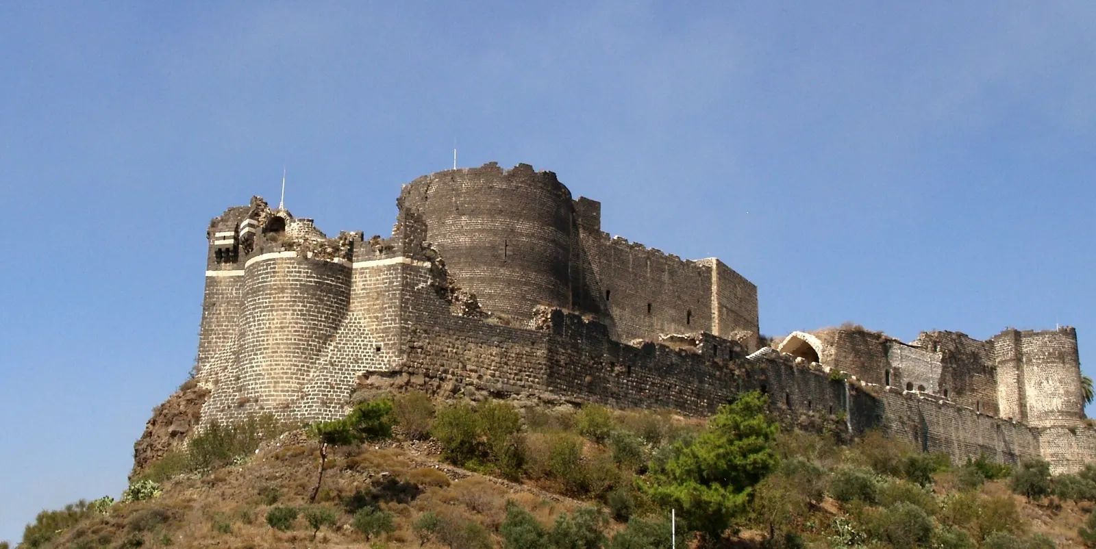
Qal'at al-Marqab / Margat Castle, a Crusader castle in northern Syria · Photo: Shayno · CC BY-SA 3.0 · Wikimedia Commons
Margat
Local name: قلعة المرقب
Margat, also known as Marqab Castle (Arabic Qalʻat al-Marqab, “castle of the watchtower”), stands on a hill formed by an extinct volcano about six kilometres south of Baniyas and around two kilometres from the Mediterranean coast. From 1186 it was a headquarters of the Knights Hospitaller in Syria, and in 1285 it fell to the Mamluk sultan Qalawun.
History
According to Arab sources cited by English Wikipedia, the site was first fortified in 1062; German Wikipedia names a local landowner as builder, while Arabic Wikipedia names Rashid al-Din al-Ismaili and traces an earlier building back to the reign of the caliph Harun al-Rashid (789–809). Byzantine forces took the castle in 1104. Accounts of how it then passed to the Principality of Antioch differ: English Wikipedia credits Tancred, German Wikipedia an exchange with Prince Roger in 1116, and Arabic Wikipedia gives 1117. The Mazoir family held it as a fief; German Wikipedia states that it was briefly back in Muslim hands between 1133 and 1140.
German Wikipedia records earthquake damage in 1157, 1170 and 1186. Because upkeep exceeded the Mazoir family's means, Bertrand Mazoir sold the castle to the Hospitallers in 1186 (on 1 February, for an annual rent of 2,000 gold bezants, according to German Wikipedia). The order rebuilt and expanded it, according to German Wikipedia until about 1205. Saladin passed by in 1188 without attacking; an Ayyubid siege in 1206 and attacks in 1269, 1270 and 1281 were repulsed.
Qalawun laid siege on 17 April 1285. After miners brought down a salient of the southern wall, the defenders surrendered on 23 May 1285 and were allowed to leave with what they could carry. Rather than destroy the castle, Qalawun repaired its defences and installed a strong garrison.[1][2][3]
Architecture
English Wikipedia describes Margat as a large spur castle with many typical elements of a concentric castle. A bent entrance leads through the base of a gate tower, and the inner defences include a large circular tower sometimes called a donjon. Unlike Krak des Chevaliers, Margat has a large outer ward, giving it a larger total area. Arabic Wikipedia describes two rings of walls with 14 towers in the outer one, a knights' hall, a chapel with 12th-century wall paintings, cisterns and a moat in front of the main entrance.[1][3]
Historical use and significance
The castle controlled the coastal road between Tripoli and Latakia. Under the Mamluks it was the seat of a district of the province of Tripoli and, in the Burji period, an imperial prison for high-profile inmates; Ibn Battuta visited its suburb in 1325. In the Ottoman period Margat was the centre of a kaza of the same name and the residence of its kaymakam until 1884, when the seat moved to Baniyas. German Wikipedia states that a small Turkish garrison remained into the 20th century.[1][2]
Timeline
- 1062
First fortification of the site; the sources name different builders.[1][2][3]
- 1104
- 1186
Bertrand Mazoir sells the castle to the Knights Hospitaller.[1][2][3]
- 1188
- 17 April – 23 May 1285
- 1884
The seat of the Ottoman kaymakam moves to Baniyas.[1]
- 2007
Some reconstruction and renovation begins.[1]
- February 2023
Damaged in the earthquake.[1]
Gallery
Documented condition
Partly damaged · as of 2023
According to English Wikipedia, the castle remained in a poor state of preservation until 2007, when some reconstruction and renovation began. It was damaged in the earthquake of February 2023; the source does not describe the extent of the damage.[1]
Visiting
Getting here
Documented ride, stay and transport services in Tartus:
Nearby medical services
Straight-line distance from this place. Data: OpenStreetMap, as of 2026-10-30. Operating status not verified – call before going.
- Baniyas National HospitalHospital · 5.8 kmDirections
- مشفى القدموس الوطنيHospital · 19 kmDirections
- مشفى الحياةHospital · 20 kmDirections
- مشفى الشيخ بدرHospital · 22 kmDirections
- Al Andalus University HospitalHospital · 22 kmDirections
- مشفى النور التخصصيHospital · 23 kmDirections
Sources (19)
- Wikipedia (en): Margat rev. 1376411121 · CC BY-SA 4.0 · 2026-10-30
- Wikipedia (de): Margat rev. 261420165 · CC BY-SA 4.0 · 2026-10-30
- Wikipedia (ar): قلعة المرقب (سوريا) rev. 70739440 · CC BY-SA 4.0 · 2026-10-30
- Wikidata · CC0 · 2026-10-30
- Wikipedia (el) · CC BY-SA 4.0 · 2026-10-30
- Wikipedia (es) · CC BY-SA 4.0 · 2026-10-30
- Wikipedia (fa) · CC BY-SA 4.0 · 2026-10-30
- Wikipedia (fr) · CC BY-SA 4.0 · 2026-10-30
- Wikipedia (hi) · CC BY-SA 4.0 · 2026-10-30
- Wikipedia (id) · CC BY-SA 4.0 · 2026-10-30
- Wikipedia (it) · CC BY-SA 4.0 · 2026-10-30
- Wikipedia (ja) · CC BY-SA 4.0 · 2026-10-30
- Wikipedia (nl) · CC BY-SA 4.0 · 2026-10-30
- Wikipedia (pl) · CC BY-SA 4.0 · 2026-10-30
- Wikipedia (pt) · CC BY-SA 4.0 · 2026-10-30
- Wikipedia (ru) · CC BY-SA 4.0 · 2026-10-30
- Wikipedia (tr) · CC BY-SA 4.0 · 2026-10-30
- Wikipedia (ur) · CC BY-SA 4.0 · 2026-10-30
- OpenStreetMap · ODbL · 2026-10-30
Quellenkonflikte: Höhe des Hügels ca. 360 m (en), 280 m (de), 370 m (ar) – nicht im Text verwendet; Lage 6 km südlich von Baniyas (en, de) vs. 5 km östlich (ar); Bauherr 1062: Muslime (en), ansässiger Grundherr (de), Rashid ad-Din al-Ismaili (ar); Übergang an Antiochia: Tankred (en) vs. Tausch mit Roger 1116 (de) vs. 1117 (ar). Die ar-Angabe einer Kirche „aus dem 2. Jahrhundert“ und eines nahen Tempels wurde nicht übernommen. Kein UNESCO-Eintrag im Paket. Zustand: nur en-Wikipedia (Renovierung ab 2007, Erdbeben 2023), keine institutionelle Schadensbewertung im Paket.