
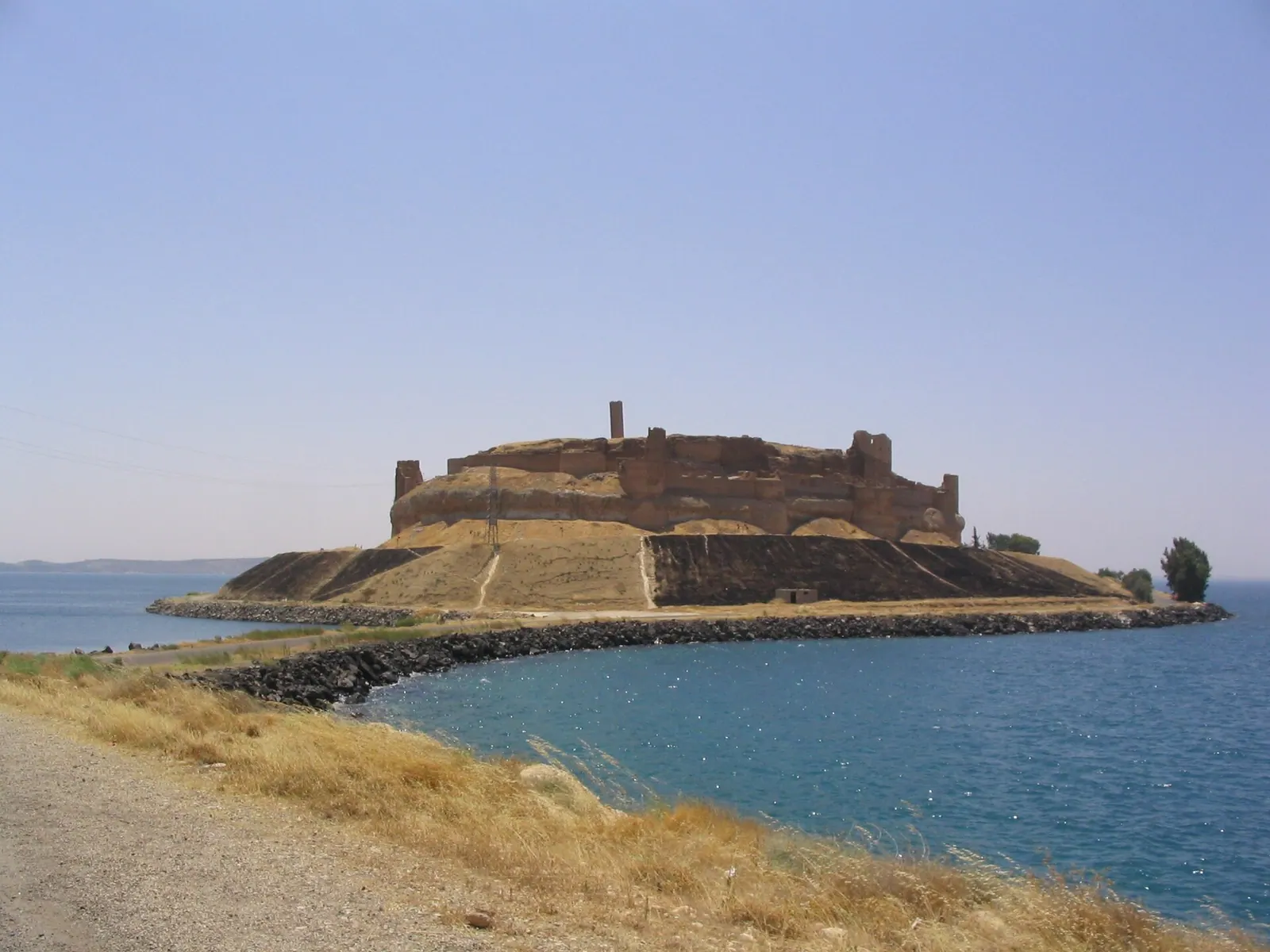
View of Qal'at Ja'bar (Syria) from the north, surrounded by the waters of Lake Assad · Photo: The original uploader was Eleman at English Wikipedia . · CC BY-SA 3.0 · Wikimedia Commons · Recorded 2008
Qal'at Ja'bar
Local name: قلعة جعبر
Qal'at Ja'bar is a castle on the left bank of Lake Assad (Euphrates Lake) in Raqqa Governorate. Its site, once a prominent hilltop over the Euphrates valley, became an island when the Tabqa Dam was built and can only be reached by an artificial causeway. The present structures are mainly the work of the Zengid ruler Nur ad-Din, who rebuilt the castle from 1168 onwards.
History
When the hill was first fortified is unknown; possibly as early as the 7th century. In pre-Islamic times the site was known as Dawsar and lay on a route from Raqqa to the west; the German and Arabic Wikipedia derive the name from a servant (slave) named Dawsar of al-Nu'man ibn al-Mundhir, king of al-Hira according to the Arabic Wikipedia. Qal'at Dawsar is mentioned in 1040/41. Its later name comes from a certain Ja'bar of the Banu Numayr or Banu Qushayr; whether he was Ja'bar ibn Sabiq or Ja'bar ibn Malik is uncertain.
In 1086 the Seljuk Malik-Shah I took the castle and granted it to the Uqaylid Salim ibn Malik in exchange for surrendering Aleppo. His descendants held it almost continuously until the late 12th century, interrupted in 1102 by the Crusaders (an occupation or a siege, depending on the source). In 1146 Zengi was murdered by one of his own slaves while besieging the castle. In 1168 his son Nur ad-Din took it over and carried out major works. It later passed to the Ayyubids and Mamluks, was heavily damaged during the Mongol invasions and restored in the 14th century.
Near the castle lay the reputed tomb of Suleyman Shah, grandfather of Osman I; he was probably confused with Sulayman ibn Kutalmish. Under Article 9 of the 1921 Treaty of Ankara the area became a Turkish exclave. In 1973 the tomb was moved north because of the rising lake, and the castle became Syrian territory.[1][2][3]
Architecture
The castle measures 370 × 170 m according to the English and German Wikipedia, 320 × 170 m according to the Arabic. A stone wall with 35 bastions surrounds a rock core and is partly fronted by a dry moat; the layout recalls the Citadel of Aleppo. The upper parts are of baked brick. Access is through a gatehouse and a winding ramp cut into the rock. Inside are the remains of a vaulted hall and a cylindrical brick minaret, built under Nur ad-Din in 1173 according to the German Wikipedia, the castle's highest point. The brickwork visible today is largely the result of restoration by the Syrian Directorate-General of Antiquities and Museums (DGAM).[1][2][3]
Restoration and excavation
Ahead of the flooding of the Euphrates valley by the Tabqa Dam, begun in 1968, excavations and restoration took place between 1965 and 1974. The castle was given a protective glacis and a causeway to the mainland; the DGAM, the dam directorate and UNESCO were involved, at a cost of LS 4 million. Work focused on the eastern walls and towers, parts of the western ramparts and the "Donjon Alia", intended to house finds; these are now in the National Museum of Aleppo and the Raqqa Museum.[1][2][3]
Timeline
Gallery
Documented condition
Current condition not documented · as of 2017
ISIS captured the castle in 2014 and, according to the English Wikipedia, built tunnels and weapons depots on the grounds. On 6 January 2017 the Syrian Democratic Forces took the castle. The sources contain no later dated condition statement; the Arabic Wikipedia describes many towers as destroyed or gone, without a date.[1][2][3]
Visiting
Getting here
Documented ride, stay and transport services in Raqqa:
Nearby medical services
Straight-line distance from this place. Data: OpenStreetMap, as of 2026-10-30. Operating status not verified – call before going.
- Al-Tabqa National HospitalHospital · 7.5 kmDirections
- HospitalHospital · 7.5 kmDirections
- البكورClinic / health centre · 8.6 kmDirections
- الطب الحديثClinic / health centre · 8.9 kmDirections
- مركز دبسي فرج الصحيHospital · 29 kmDirections
Sources (15)
- Wikipedia (en): Qal'at Ja'bar rev. 1381456359 · CC BY-SA 4.0 · 2026-10-30
- Wikipedia (de): Qalʿat Dschaʿbar rev. 254842124 · CC BY-SA 4.0 · 2026-10-30
- Wikipedia (ar): قلعة جعبر rev. 76080330 · CC BY-SA 4.0 · 2026-10-30
- Wikidata · CC0 · 2026-10-30
- Wikipedia (es) · CC BY-SA 4.0 · 2026-10-30
- Wikipedia (fa) · CC BY-SA 4.0 · 2026-10-30
- Wikipedia (fr) · CC BY-SA 4.0 · 2026-10-30
- Wikipedia (id) · CC BY-SA 4.0 · 2026-10-30
- Wikipedia (it) · CC BY-SA 4.0 · 2026-10-30
- Wikipedia (nl) · CC BY-SA 4.0 · 2026-10-30
- Wikipedia (pl) · CC BY-SA 4.0 · 2026-10-30
- Wikipedia (ru) · CC BY-SA 4.0 · 2026-10-30
- Wikipedia (tr) · CC BY-SA 4.0 · 2026-10-30
- Wikipedia (ur) · CC BY-SA 4.0 · 2026-10-30
- OpenStreetMap · ODbL · 2026-10-30
Maße 370 × 170 m (en, de) vs. 320 × 170 m (ar). Kreuzfahrer 1102: Besetzung (en) vs. Belagerung (de). Namengeber: Dschaʿbar ibn Sābiq (en, de) vs. Dschaʿbar ibn Mālik al-Qushairī (ar; de nennt beide). Herkunft des Namens Dausar: de sagt Ghassaniden-Kontrolle, nennt aber an-Nuʿmān ibn al-Mundhir; ar nennt ihn König von al-Hira – im Text nach ar wiedergegeben, die de-Zuordnung zu den Ghassaniden redaktionell prüfen. Minarett 1173 nur in de. Die ar-Angabe, die Burg sei für Besucher geöffnet und ein Turm sei Museum, wurde nicht übernommen (Besuchsangaben ausgeschlossen; de sagt, die Ausstellung im Donjon kam nicht zustande). Grabverlegung 1973 und spätere Exklavengeschichte (2015 Räumung) betreffen den neuen Standort, nicht die Burg. Kein UNESCO-Eintrag im Paket; UNESCO nur als Beteiligte der Arbeiten 1965–1974 genannt.