
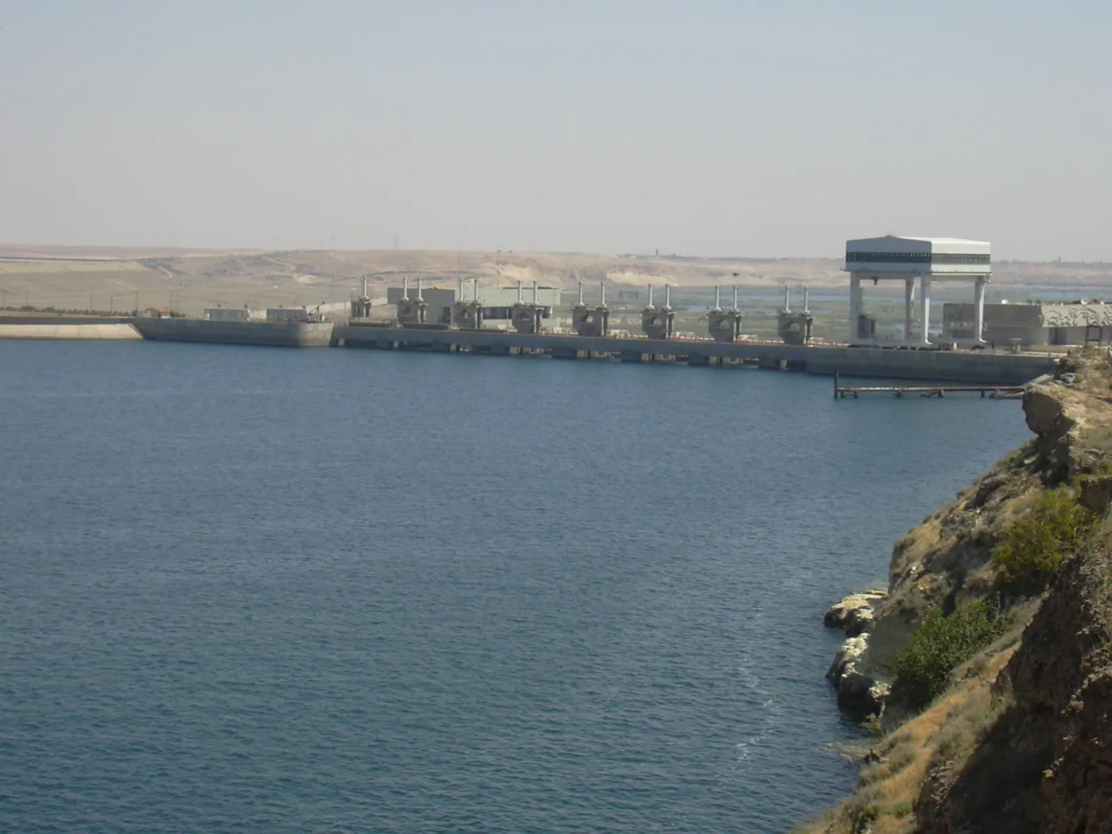
Terminal power station at Lake Assad · Photo: Herbert Frank from Wien (Vienna), AT · CC BY 2.0 · Wikimedia Commons · Recorded 2006
Euphrates Dam
Local name: سد الطبقة
The Euphrates Dam, commonly known as Tabqa Dam, is an earth-fill dam on the Euphrates in Raqqa Governorate and the largest dam in Syria; it impounds the country's largest reservoir. Built from 1968 with Soviet assistance, it serves power generation and irrigation. The facility is included in the atlas as infrastructure; its inclusion says nothing about public or tourist access.
Facts
The dam lies immediately north of the city of Al-Thawrah (Tabqa), about 40 km upstream of Raqqa (other sources: 35 or 50 km). It is 4.5 km long, 60 m high above the riverbed, 512 m wide at the base and 19 m at the crest. A 250 m spillway with two openings serves as flood relief. The hydroelectric station at the southern end has eight Kaplan turbines of up to 103 MW each; the German Wikipedia gives an installed capacity of 824 MW.
The reservoir – Euphrates Lake, called Lake Assad in the German Wikipedia – is about 80 km long and on average 8 km wide. Its potential capacity is given as 11.7 km³; the actual capacity is given as 9.6 km³ with a surface of 447 km².[1][2][3]
History
A Euphrates dam was first proposed in 1927 under the French Mandate. After agreements with the Soviet Union (1957), with West Germany on a loan (1960) and again with the Soviet Union (1965), construction began in 1968. It lasted until 1973 (German Wikipedia: 1974); the power station was completed on 8 March 1978. The cost was US$340 million, of which US$100 million was a Soviet loan; up to 12,000 Syrians and 900 Soviet technicians worked on the project. According to the English Wikipedia, around 4,000 Arab families from the flooded valley were resettled as part of a partially implemented plan for an "Arab belt" along the borders.
Filling the reservoir from 1974, as Turkey filled the Keban Dam during a drought, led to a dispute with Iraq; both states sent troops to the border. An agreement was reached in 1975 through Saudi and Soviet mediation.
On 11 February 2013 opposition forces took the dam (German Wikipedia: rebels around the Nusra Front), and in 2014 the Islamic State. During an SDF–US operation on 26 March 2017 US bombs struck the facility; critical equipment failed and the dam stopped functioning. After an emergency ceasefire, repairs were made and floodgates opened on 29 March and 5 April; the flooding displaced about 3,000 people. The SDF took the dam on 10 May 2017. In January 2026 government forces took control (ar: evening of 17 January; en, citing SANA: 18 January).[1][2][3]
Significance
The planning goals were only partly met: of 640,000 ha intended for irrigation, about 124,000 ha (19%) were irrigated in 2000, partly due to gypsum-rich, salinising soils and collapsed canals. Because of lower inflow from Turkey and lack of maintenance, the English Wikipedia states that the plant generates only 150 MW instead of 800 MW. The lake is Aleppo's most important source of drinking water and supports fishing; its shores are a wintering area for migratory birds, and the island of Jazirat al-Thawra is a nature reserve.
Before flooding, sites were surveyed from 1963, and an international rescue programme, supported by UNESCO from 1971, excavated more than 25 of them, among them Mureybet, Emar and Abu Hureyra; the minarets of Mureybet and Meskene were moved and the castle of Qal'at Ja'bar was protected.[1][2][3]
Timeline
- 1927
First proposal for a Euphrates dam under the French Mandate.[1][3]
- 1968–1973
Construction of the dam with Soviet assistance (March 1968 to 1974 according to the German Wikipedia).[1][2][3]
- 1974–1975
Filling of the reservoir; dispute with Iraq over the water flow, settled in 1975 through Saudi and Soviet mediation.[1][2][3]
- 8 March 1978
- 11 February 2013
- 2014
- March–May 2017
US air strike on 26 March stops the dam; emergency repairs and opening of floodgates; the SDF take control on 10 May.[1][2][3]
- January 2026
Government forces take control (17 or 18 January depending on the source).[1][3]
Gallery
Documented condition
Current condition not documented · as of 2026
Visiting
Getting here
Documented ride, stay and transport services in Raqqa:
Nearby medical services
Straight-line distance from this place. Data: OpenStreetMap, as of 2026-10-30. Operating status not verified – call before going.
- الطب الحديثClinic / health centre · 5.1 kmDirections
- البكورClinic / health centre · 5.1 kmDirections
- Al-Tabqa National HospitalHospital · 5.2 kmDirections
- HospitalHospital · 5.2 kmDirections
Sources (17)
- Wikipedia (en): Euphrates Dam rev. 1362067391 · CC BY-SA 4.0 · 2026-10-30
- Wikipedia (de): Tabqa-Talsperre rev. 267020847 · CC BY-SA 4.0 · 2026-10-30
- Wikipedia (ar): سد الفرات rev. 76356574 · CC BY-SA 4.0 · 2026-10-30
- Wikidata · CC0 · 2026-10-30
- Wikipedia (es) · CC BY-SA 4.0 · 2026-10-30
- Wikipedia (fa) · CC BY-SA 4.0 · 2026-10-30
- Wikipedia (fr) · CC BY-SA 4.0 · 2026-10-30
- Wikipedia (id) · CC BY-SA 4.0 · 2026-10-30
- Wikipedia (it) · CC BY-SA 4.0 · 2026-10-30
- Wikipedia (ko) · CC BY-SA 4.0 · 2026-10-30
- Wikipedia (nl) · CC BY-SA 4.0 · 2026-10-30
- Wikipedia (pl) · CC BY-SA 4.0 · 2026-10-30
- Wikipedia (pt) · CC BY-SA 4.0 · 2026-10-30
- Wikipedia (ru) · CC BY-SA 4.0 · 2026-10-30
- Wikipedia (sv) · CC BY-SA 4.0 · 2026-10-30
- Wikipedia (tr) · CC BY-SA 4.0 · 2026-10-30
- Wikipedia (zh) · CC BY-SA 4.0 · 2026-10-30
Widersprüche: (1) Bauzeit – en/ar 1968–1973 (ar: Projekt nach Flussumleitung 1974 abgeschlossen), de März 1968 bis 1974, aufgestaut ab 1973; de nennt zudem eine Einweihung durch Hafiz al-Assad 1993 – nicht übernommen, da isoliert und unplausibel gegenüber Kraftwerksfertigstellung 1978, fachlich prüfen. (2) Entfernung zu ar-Raqqa: de 35 km, en 40 km, ar 50 km. (3) Leistung: geplant 880 MW (en/ar), 8 × 10³ MW, installiert 824 MW (de); tatsächliche Erzeugung 150 statt 800 MW (en/ar, ohne Bezugsjahr). (4) Seefläche: 447 km² tatsächlich (en), 610 km² bei Vollstau (en/ar), de nennt 610–817 km² je nach Quelle; Volumen 11,7 km³ (en), 11 km³ bzw. ca. 12 Mrd. m³ (de), über 11,6 Mrd. m³ (ar). (5) Februar 2013: en/ar „Opposition“ (nach SOHR), de „Rebellen um die Al-Nusra-Front“. (6) Januar 2026: en (nach SANA) 18. Januar, ar Abend des 17. Januar. (7) ar schreibt beim Abkommen von 1987 „16 km³ täglich“ (offensichtlich Fehler; en: pro Jahr) – Abkommen 1987 nicht in den Text übernommen. (8) Seename: Euphratsee (en/ar) bzw. Assadsee/بحيرة الأسد (de/ar). Bewertung „unvollständig erreichte Ziele“ folgt en/ar. Nicht übernommen: Museumspräsentation in Aleppo (aktueller Stand unklar), Grab des Sulaiman Schah (de; betrifft eigenes Objekt). Wikidata-Koordinaten im Paket vorhanden (35.8722, 38.5667), Inception 1968. Keine relations gesetzt: P131 = Q283368 steht im Paket ohne Label; Euphratsee, Mansoura- und Tischrin-Talsperre ohne QID im Paket – bei Bedarf ergänzen. altNames nur aus den Quellen (en: al-Thawra Dam, Kurdisch Bendava Firatê; de: ath-Thaura-Damm, Sadd al-Furat, Euphrat-Staudamm).