
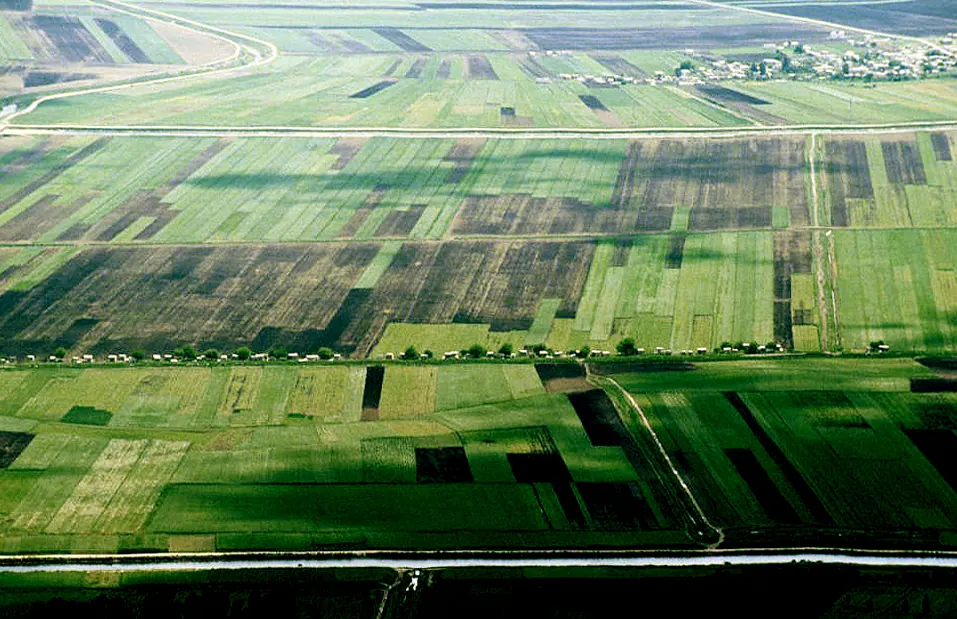
Al-Ghab Plain, Hama, Syria · Photo: LBM1948 · CC BY-SA 4.0 · Wikimedia Commons · Recorded 2001
Ghab Plain
Local name: سهل الغاب
The Ghab Plain (Arabic Sahl al-Ghab, “forest plain”) is a fertile depression on the Orontes, lying mainly in al-Suqaylabiyah District of Hama Governorate. A swamp for centuries, it was drained by the Ghab project from 1953 and is now one of Syria's major farming areas.
Landscape
The plain is a long, narrow rift valley which German Wikipedia assigns to the northern extension of the Great Rift Valley. It is bounded by the al-Ansariyah mountains to the west and the Zawiyah range, the southern part of the northern Syrian Limestone Massif, to the east. The north-flowing Orontes enters the plain near Muhradah, about 25 km north-west of Hama.
Dimensions differ between sources: English Wikipedia gives 63 km by 12.1 km, German Wikipedia about 60 km by 10–15 km, Arabic Wikipedia 80 km by 10–15 km. To the north-east lies the smaller, agriculturally prosperous al-Ruj Plain west of Idlib, which contains many ancient sites.[1][2][3]
History
Before its drainage the Ghab was the centre of catfish fishing in the Orontes valley. German Wikipedia notes that dykes and dams built in antiquity had already turned the western end into farmland. The Ghab project, begun in 1953, combined barrages with irrigation and drainage canals and added 41,000 hectares of farmland; by 1968 the plain was fully drained and provided land for 11,000 families.
The Mahardah dam, built in 1961, is 40 m high and 200 m long and holds 65 million m³. The Zeyzoun Dam, built in 1996, was 32 m high (71 million m³); it failed in June 2002, killing 22 people, displacing more than 2,000 and flooding 80 km² downstream. Drainage made roads and railways possible and reduced malaria. In the 1980s a road to the coast via Beit Yashout was built.[1][2][3]
Significance
According to Arabic Wikipedia about 325,000 people lived in the plain in 2010, mostly working in agriculture. Crops include cotton, sugar beet, sunflowers, wheat, tobacco and vegetables, and the plain is also important for fish farming and cattle. The main towns are al-Suqaylabiyah and Salhab; historic castles on its edges include, above all, that of Afamia.[1][2][3]
Timeline
Gallery
Documented condition
Current condition not documented
Visiting
Getting here
Documented ride, stay and transport services in Hama:
Nearby medical services
Straight-line distance from this place. Data: OpenStreetMap, as of 2026-10-30. Operating status not verified – call before going.
- HospitalHospital · 9.5 kmDirections
- مشفى دار الحكمةHospital · 19 kmDirections
- Al-Jisr Hospital (Kidney)Hospital · 25 kmDirections
- Jisr al-Shughur Specialized HospitalHospital · 25 kmDirections
- HospitalHospital · 27 kmDirections
- National Hospital in QardahaHospital · 29 kmDirections
Sources (8)
- Wikipedia (en): Ghab Plain rev. 1362884528 · CC BY-SA 4.0 · 2026-10-30
- Wikipedia (de): Ghab-Ebene rev. 259108104 · CC BY-SA 4.0 · 2026-10-30
- Wikipedia (ar): سهل الغاب rev. 76940532 · CC BY-SA 4.0 · 2026-10-30
- Wikidata · CC0 · 2026-10-30
- Wikipedia (es) · CC BY-SA 4.0 · 2026-10-30
- Wikipedia (nl) · CC BY-SA 4.0 · 2026-10-30
- Wikipedia (tr) · CC BY-SA 4.0 · 2026-10-30
- Wikipedia (zh) · CC BY-SA 4.0 · 2026-10-30
Maße widersprüchlich: 63 × 12,1 km (en), ca. 60 × 10–15 km (de), 80 × 10–15 km (ar) – alle genannt. Name en: Wikidata-Label „Al-Ghab plain“, en-Titel „Ghab Plain“ (verwendet). Ortsname Mhardeh/Muhradah/Mahardah je nach Quelle. Die ar-Angabe „Burg Simʿan“ am Rand der Ebene nicht übernommen (unklar). Bevölkerungszahl 2010 und Stammesnamen nur in ar; Stammesliste nicht übernommen. Keine Angaben zur Lage nach 2011 in den Quellen.