
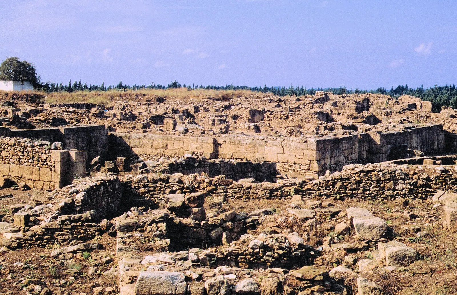
Ugarit · Photo: Haubi|Gerhard Haubold · CC BY-SA 4.0 · Wikimedia Commons · Recorded 1994
Ugarit
Local name: أوغاريت
Ugarit was a Bronze Age port city on the coast of northern Syria, whose ruins lie in the mound of Ras Shamra some 10 to 12 kilometres north of Latakia. In the Late Bronze Age it was the capital of a trading kingdom, and its tablet archives preserve the oldest known systematic use of an alphabet. Syria placed the site on its UNESCO Tentative List in 1999.
History
The site was occupied from the Neolithic onward; English Wikipedia gives the end of the 8th millennium BC, German Wikipedia the 7th. It became urban from the early 3rd millennium, was abandoned around 2200 BC, and was resettled and fortified in the Middle Bronze Age. The Mari archive (c. 1765 BC) mentions Ugarit and a visit by King Zimri-Lim; the city was then a vassal of the kingdom of Yamhad, centred on Aleppo. Finds attest contacts with Middle Kingdom Egypt.
Its golden age came in the Late Bronze Age. Ugarit traded with Egypt, Cyprus, the Aegean, the Hittites and the cities of the Levant, and its population is estimated at 6,000 to 8,000. Under Niqmaddu II (c. 1350–1315 BC) it became a Hittite vassal while keeping broad economic and cultural independence. Letters in the Amarna archive document diplomatic ties with Egypt.
Around 1200 BC the eastern Mediterranean suffered famine while seaborne raiders struck the coast. The last king, Ammurapi, appealed for help in vain, since his army and fleet were serving the Hittites. The city was sacked and burned, probably by the so-called Sea Peoples. Dates range between 1194 and 1185 BC; English Wikipedia reports that radiocarbon and astronomical data point to 1192–1190 BC. Ugarit was never rebuilt.[1][2][3]
Site and buildings
The mound covers about 28 hectares and rises up to 20 metres; a city wall with one known fortified gate enclosed the town. In the west lay the Royal Zone with the palace, which grew around courtyards in several phases during the 14th and 13th centuries BC. Its size varies by source: about 6,500 m² (English Wikipedia), about 10,000 m² with some 100 rooms (German Wikipedia), nearly one hectare (UNESCO). The stone ground floor survives in places up to 4 metres high, and numerous staircases attest a lost upper storey.
On the acropolis stood the temples of Baal and Dagan, each with a porch and an inner sanctuary. The Temple of Baal was destroyed in the mid-13th century BC, possibly by an earthquake, and not rebuilt, whereas the Temple of Dagan was restored. Between them stood the House of the High Priest. In the city centre the so-called Temple of the Rhyton sat within a residential quarter. Houses followed a common type with vestibule, courtyard and staircase, lining narrow, irregular lanes.
The kingdom included the harbour of Minet el-Beida, about 1.5 to 2 kilometres west, and the secondary residence of Ras Ibn Hani, about 5 kilometres south.[1][2][4]
Use and significance
Ugarit was a trading hub, a royal seat and a religious centre. Stelae, statues and sixteen stone anchors were found as votive offerings at the Temple of Baal. The House of the High Priest held tablets of mythological poetry, including the Baal cycle, along with writing exercises and word lists that point to a scribal school. The Temple of the Rhyton has also been interpreted as a venue for the marzeah, a communal feast in honour of a deity.
After its destruction the site lay abandoned for centuries; a small village existed nearby in the 6th to 4th centuries BC, and there was brief settlement in Roman times. The acropolis was later looted and quarried. In 1928 a farmer ploughing a field accidentally opened a tomb in the necropolis of Minet el-Beida. A French mission under Claude Schaeffer excavated from 1929, later under other directors and from 2005 jointly with Syria, until the civil war halted work in 2011.[1][2][4]
Notable features
Around 1400 BC, or from the 14th century BC, scribes at Ugarit developed an alphabetic cuneiform of 30 signs whose letter order resembles the Phoenician. Akkadian served alongside it as the language of diplomacy. According to UNESCO, inscribed bronze tools allowed the script to be deciphered in 1930; German Wikipedia credits Hans Bauer (1932), Charles Virolleaud and Édouard Dhorme.
The tablets also include Hurrian hymns regarded as the oldest surviving musical notation. Synchronisms in the texts, such as with the Egyptian chancellor Bay, have refined the chronology of the eastern Mediterranean. UNESCO notes that after sixty years of research only one sixth of the site had been excavated.[1][2][4]
Timeline
- 8th/7th mill. BC
First Neolithic settlement (date varies by source).[1][2][3]
- c. 1765 BC
The Mari archive mentions Ugarit and a visit by Zimri-Lim.[1][2][3]
- c. 1400 BC
- c. 1350–1315 BC
- 1194–1185 BC
Destruction of the city (radiocarbon and astronomical data suggest 1192–1190 BC).[1][2][3]
- 1928
- 1929–2011
Excavations by the French, from 2005 French-Syrian, mission, paused 1939–1950; halted by the civil war in 2011.[1][2]
- 1999
Gallery
Documented condition
Current condition not documented · as of 2011
Since the Late Bronze Age the Nahr Chbayyeb river has eroded about 50 metres from the north end of the mound, and orange groves on the southern slope prevent excavation. Minet el-Beida is now a military port and unavailable for excavation. Excavations were interrupted by the civil war in 2011; English Wikipedia reports that many arrowheads were recovered from the destruction level in 2021. The sources contain no information on war damage or the current state of preservation.[1]
Visiting
Getting here
Documented ride, stay and transport services in Latakia:
Nearby medical services
Straight-line distance from this place. Data: OpenStreetMap, as of 2026-10-30. Operating status not verified – call before going.
- مركز صحيHospital · 4.5 kmDirections
- مركز الدعتور الطبيHospital · 5.5 kmDirections
- مستوصف الشهيد نوار غسان يوسفHospital · 6 kmDirections
- مستشفى سويدHospital · 6.7 kmDirections
- مشفى زاهي أزرق العسكريHospital · 7.3 kmDirections
- مشفى الندىHospital · 7.9 kmDirections
Sources (24)
- Wikipedia (en): Ugarit rev. 1374559696 · CC BY-SA 4.0 · 2026-10-30
- Wikipedia (de): Ugarit rev. 270713782 · CC BY-SA 4.0 · 2026-10-30
- Wikipedia (ar): أوغاريت rev. 76573289 · CC BY-SA 4.0 · 2026-10-30
- UNESCO World Heritage Centre, Tentative List: Ugarit (Tell Shamra) (1292) · 2026-10-30
- Wikidata · CC0 · 2026-10-30
- Wikipedia (el) · CC BY-SA 4.0 · 2026-10-30
- Wikipedia (es) · CC BY-SA 4.0 · 2026-10-30
- Wikipedia (fa) · CC BY-SA 4.0 · 2026-10-30
- Wikipedia (fr) · CC BY-SA 4.0 · 2026-10-30
- Wikipedia (hi) · CC BY-SA 4.0 · 2026-10-30
- Wikipedia (id) · CC BY-SA 4.0 · 2026-10-30
- Wikipedia (it) · CC BY-SA 4.0 · 2026-10-30
- Wikipedia (ja) · CC BY-SA 4.0 · 2026-10-30
- Wikipedia (ko) · CC BY-SA 4.0 · 2026-10-30
- Wikipedia (nl) · CC BY-SA 4.0 · 2026-10-30
- Wikipedia (pl) · CC BY-SA 4.0 · 2026-10-30
- Wikipedia (pt) · CC BY-SA 4.0 · 2026-10-30
- Wikipedia (ru) · CC BY-SA 4.0 · 2026-10-30
- Wikipedia (sv) · CC BY-SA 4.0 · 2026-10-30
- Wikipedia (tr) · CC BY-SA 4.0 · 2026-10-30
- Wikipedia (ur) · CC BY-SA 4.0 · 2026-10-30
- Wikipedia (zh) · CC BY-SA 4.0 · 2026-10-30
- UNESCO World Heritage Centre · © UNESCO (link only) · 2026-10-30
- OpenStreetMap · ODbL · 2026-10-30
Quellenkonflikte: Entfernung von Latakia 10 km (en) / 11 km (de) / 12 km (ar); Beginn der Besiedlung Ende 8. Jt. (en), 7. Jt. (de), 7500 v. Chr. (ar), Wikidata-Inception −6000 und en „c. 6000 BC“; Zerstörung c. 1185 (en Einleitung, ar), 1192–1190 (en, Radiokarbon), 1194–1185 (de); Palastfläche 6500 m² (en) vs. ca. 10.000 m² (de, ar) vs. knapp 1 ha (UNESCO), en nennt 10.000 m² zugleich für die Königszone; Blütezeit 1500–1200 (en) vs. 1350–1190 (de); Fläche des Königreichs ca. 2000 km² (en) vs. 5425 km² (ar, nicht übernommen); Lage der Akropolis im Nordwesten vs. Nordosten innerhalb des en-Artikels; Entfernung Minet el-Beida 1,5 km (en) vs. 2 km (de); Entzifferung 1930 (UNESCO) vs. Bauer 1932 (de, Vorstellung der Ergebnisse). Die de-Wikipedia schreibt die Hilfeverweigerung aus Karkemiš fest, die en-Wikipedia berichtet, Truppen seien geschickt worden, aber zu spät gekommen – im Text neutral als „vergeblich“ wiedergegeben. Nicht übernommen: Homer-Zitat (ar, unbelegt) und die Deutung des KTU-Textes als Adam-und-Eva-Erzählung (de). UNESCO-Eintrag ist der Tentativlisten-Eintrag 1292 (Text im Paket gekürzt); Wikidata nennt die URL-Form tentativelists/1292, verwendet wurde die Form aus dem Paket-Kopf. Der Fundbericht über Pfeilspitzen 2021 (en) ist ohne Kontext zur Grabungstätigkeit; kein Zustandsbericht nach 2011 vorhanden.