
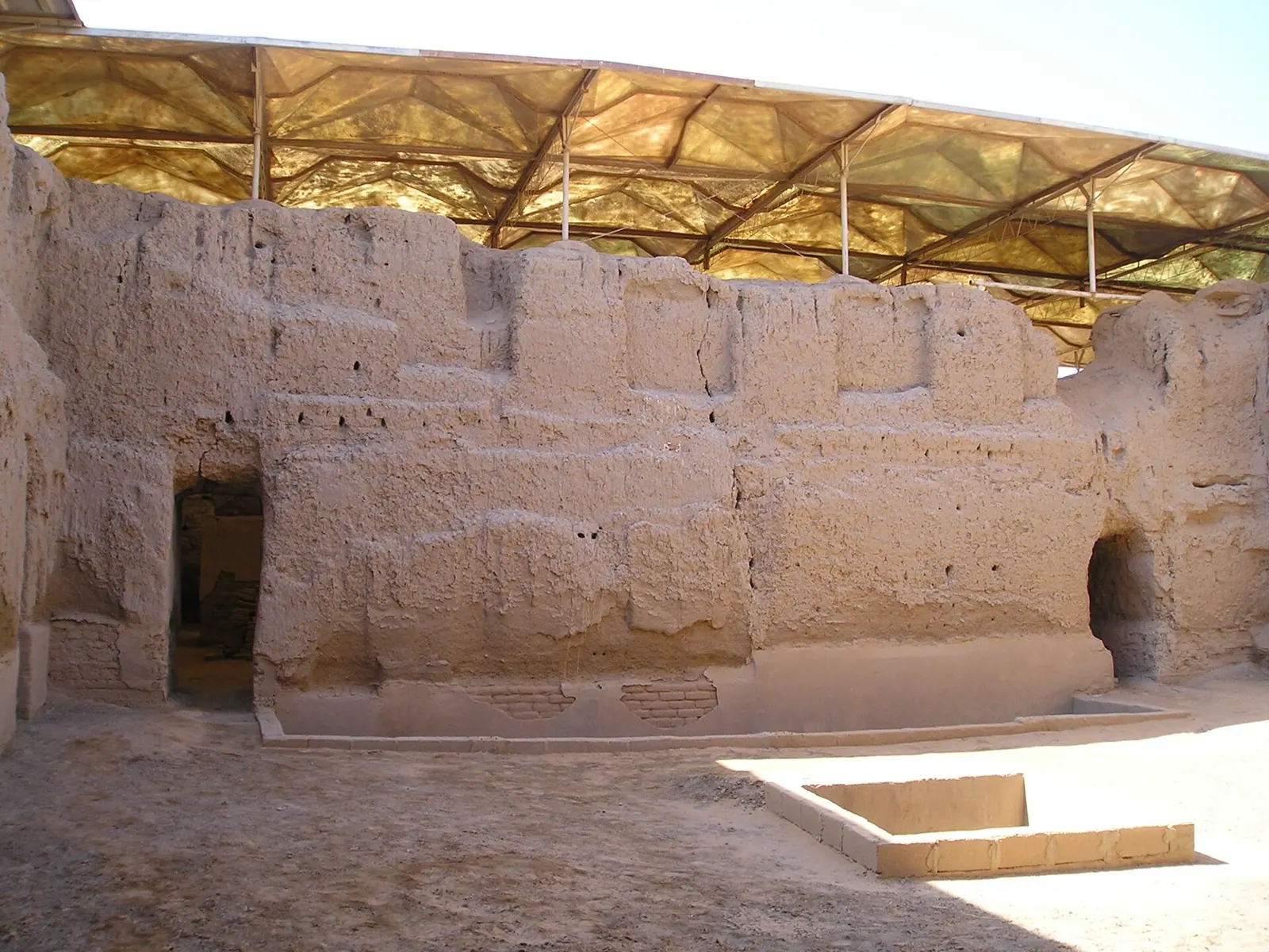
Mari, Syria: remains of the Palace of Zimri-Lim · Photo: Heretiq · CC BY-SA 2.5 · Wikimedia Commons · Recorded 2005
Mari
Local name: مملكة ماري
Mari, modern Tell Hariri, was a Bronze Age city-state on the western bank of the Euphrates, about 11 kilometres northwest of Abu Kamal. Founded around 2900 BC as a planned circular city, it controlled the trade routes between Sumer and the Levant until it was destroyed by Hammurabi of Babylon in the 18th century BC. Its palaces and more than 20,000 cuneiform tablets, excavated since 1933, make it a key site for the history of Syria and Mesopotamia.
History
According to English Wikipedia and UNESCO, Mari was founded around 2900 BC as a new city to control the Euphrates waterways; German Wikipedia considers its foundation undocumented. The first city (“Ville I”) was abandoned around 2550 BC for unknown reasons, rebuilt before 2500 BC and, as the “second kingdom”, became a powerful state with strong Sumerian cultural affinities that fought a long war with Ebla. Around 2300 BC (middle chronology) Sargon of Akkad destroyed the city.
After its restoration under Akkadian rule, military governors (Shakkanakku) governed Mari and became independent as the Akkadian Empire disintegrated. Around 1830 BC the Amorite Lim dynasty took over; under Zimri-Lim (from about 1776 BC) the kingdom flourished. Hammurabi of Babylon defeated him around 1761 BC and razed the city after a revolt; German Wikipedia gives 1759 BC (middle chronology). Mari survived as a small settlement under Babylonian and Assyrian rule until it disappeared from records in the Hellenistic period.
The site was discovered in 1933 when Bedouin digging for a gravestone found a headless statue; a Louvre team began excavating on 14 December 1933. Excavations were directed by André Parrot (until 1974), Jean-Claude Margueron (1979–2004) and, from 2005, Pascal Butterlin; UNESCO counts 42 campaigns.[1][2][4][5]
Site
The first city had a strictly circular plan about 1.9 kilometres in diameter (German Wikipedia and the serial tentative entry: about 2 km), protected by an outer flood embankment and an inner rampart with towers, and linked to the Euphrates by a canal. Palace and temples stood at the centre, including the “Enceinte Sacrée” and temples of Ninhursag, Ishtar and Shamash; under the Shakkanakku a “Temple of the Lions” for Dagan was added.
The palace of Zimri-Lim had 275 rooms according to English Wikipedia; the UNESCO description gives more than 2.5 hectares with some 300 rooms and courtyards and mud-brick walls preserved up to four to five metres high with wall paintings. According to UNESCO, the tell, formed by three superimposed cities, covers more than 14 hectares and rises up to 14.5 metres.[1][2][4][5]
Historical use and significance
The tablet archives – over 25,000 tablets in all according to English Wikipedia, more than 20,000 of them from Zimri-Lim's archive of about 1800–1750 BC – document administration, diplomacy and trade networks reaching Afghanistan and Crete. Semitic and Sumerian deities were worshipped, with Dagan at the head of the pantheon. Finds are held in the Louvre, the national museums of Aleppo and Damascus and the Deir ez-Zor Museum. Mari has been on Syria's Tentative List since 1999 and also appears, together with Dura-Europos, in a further tentative entry.[1][2][4][5]
Timeline
Documented condition
Heavily damaged · as of 2022
Excavations have been suspended since 2011. The site came under the control of armed groups; a 2014 official report named the palace, the baths and the temples of Ishtar and Dagan as looters' targets. According to German Wikipedia, ISIS fighters dug tunnels into the palace and blew up the protective cover installed in 2010; in spring 2018 Mari was considered the most looted site in the country. English Wikipedia reports remote-sensing evidence of extensive looting between 2011 and 2022.[1][2]
Visiting
Getting here
Documented ride, stay and transport services in Deir ez-Zor:
Nearby medical services
Straight-line distance from this place. Data: OpenStreetMap, as of 2026-10-30. Operating status not verified – call before going.
- مشفى البوكمال العامHospital · 9.6 kmDirections
- مشفى هجين العامHospital · 18 kmDirections
Sources (24)
- Wikipedia (en): Mari, Syria rev. 1382056034 · CC BY-SA 4.0 · 2026-10-30
- Wikipedia (de): Mari (Stadt) rev. 268997674 · CC BY-SA 4.0 · 2026-10-30
- Wikipedia (ar): مملكة ماري rev. 75446194 · CC BY-SA 4.0 · 2026-10-30
- UNESCO World Heritage Centre, Tentative List: Mari (Tell Hariri) · 2026-10-30
- UNESCO World Heritage Centre, Tentative List: Mari and Europos-Dura · 2026-10-30
- Wikidata · CC0 · 2026-10-30
- Wikipedia (el) · CC BY-SA 4.0 · 2026-10-30
- Wikipedia (es) · CC BY-SA 4.0 · 2026-10-30
- Wikipedia (fa) · CC BY-SA 4.0 · 2026-10-30
- Wikipedia (fr) · CC BY-SA 4.0 · 2026-10-30
- Wikipedia (id) · CC BY-SA 4.0 · 2026-10-30
- Wikipedia (it) · CC BY-SA 4.0 · 2026-10-30
- Wikipedia (ja) · CC BY-SA 4.0 · 2026-10-30
- Wikipedia (ko) · CC BY-SA 4.0 · 2026-10-30
- Wikipedia (nl) · CC BY-SA 4.0 · 2026-10-30
- Wikipedia (pl) · CC BY-SA 4.0 · 2026-10-30
- Wikipedia (pt) · CC BY-SA 4.0 · 2026-10-30
- Wikipedia (ru) · CC BY-SA 4.0 · 2026-10-30
- Wikipedia (sv) · CC BY-SA 4.0 · 2026-10-30
- Wikipedia (tr) · CC BY-SA 4.0 · 2026-10-30
- Wikipedia (ur) · CC BY-SA 4.0 · 2026-10-30
- Wikipedia (zh) · CC BY-SA 4.0 · 2026-10-30
- UNESCO World Heritage Centre · © UNESCO (link only) · 2026-10-30
- OpenStreetMap · ODbL · 2026-10-30
Tentativliste 1999 nach en- und de-Wikipedia (Weblinks „Suggestion … in 1999“); Jahr des gemeinsamen Eintrags 5702 (Mari und Europos-Dura) im Paket nicht genannt; Titel des Eintrags 5702 aus dem Seiteninhalt erschlossen. Konflikte: Gründung um 2900 v. Chr. (en, UNESCO) vs. „Angaben nicht bekannt“ (de); UNESCO 1294 nennt widersprüchlich eine Gründung „au XVIIIe siècle“ (offensichtlicher Fehler, nicht übernommen); Zerstörung durch Hammurapi um 1761 (en) vs. 1759 v. Chr. (de; en: Aufstand 1759, danach Schleifung); Stadtdurchmesser 1,9 km (en, UNESCO 1294) vs. ca. 2 km (de, UNESCO 5702); Wall 6,7 m dick, 8–10 m hoch (en) vs. ca. 6 m / 8 m (UNESCO 5702); Palast 275 Räume (en) vs. ca. 300 Räume und Höfe (UNESCO 1294); Tafelzahl über 25.000 (en) vs. über 20.000 (de) vs. ca. 15.000 im Palast (UNESCO 1294). ar-Label lautet „مملكة ماري“ (Königreich Mari). Zustand: keine UNESCO-Zustandsbewertung im Paket; Status „heavily-damaged“ auf Basis von „am stärksten geplünderte Stätte“ (de) und flächigen Raubgrabungslöchern (en).