
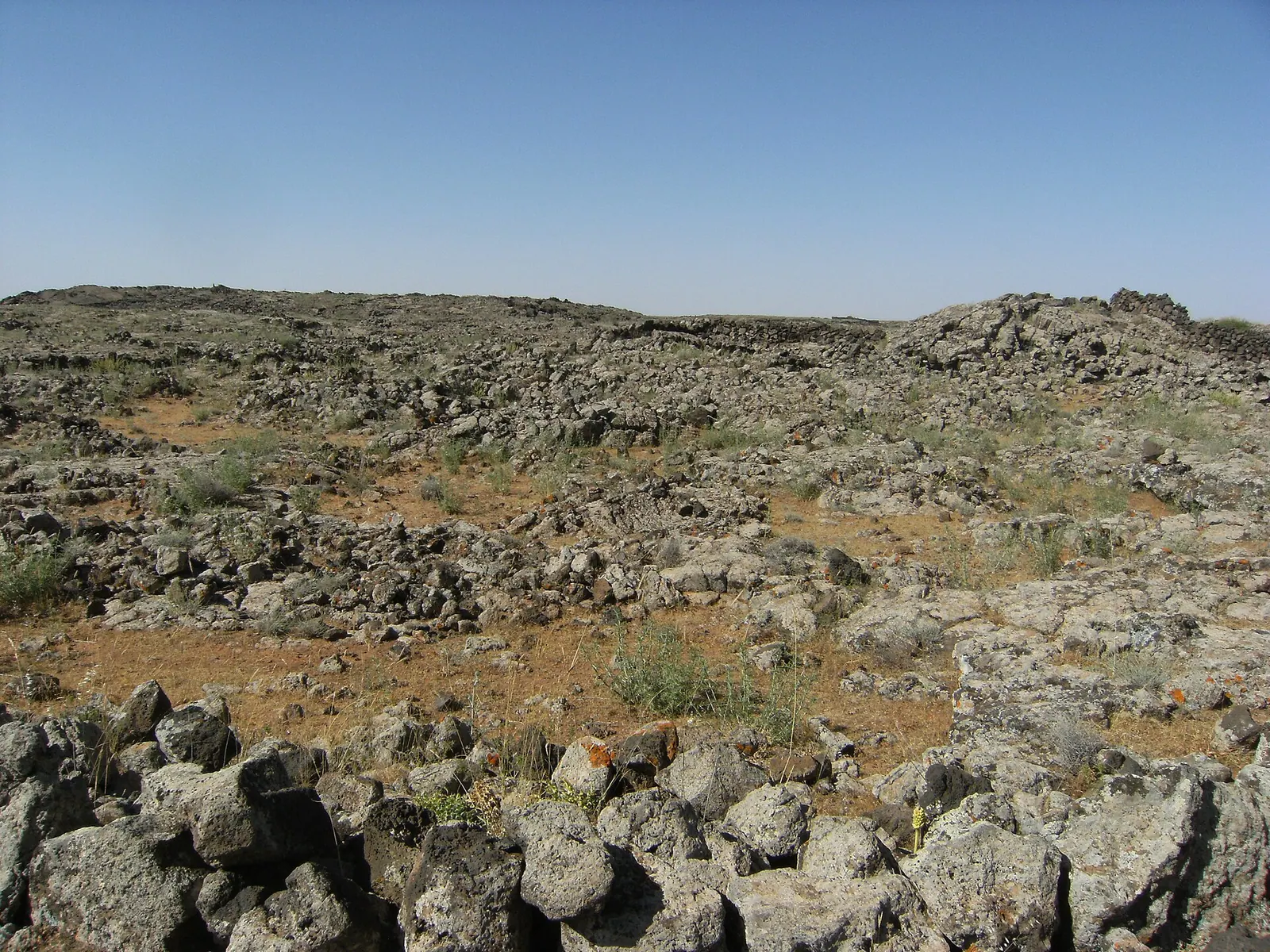
Lajat biosphere reserve, volcanic plates, Syria · Photo: Anas Qtiesh · CC BY 2.0 · Wikimedia Commons · Recorded 2009
Lajat
Local name: اللجاة
The Lajat (Arabic al-Lajāʾ, “the refuge”), known in antiquity as Trachonitis, is the largest lava field in southern Syria, about 50 km south to south-east of Damascus between the Hauran plain and Jabal al-Druze. Its rugged basalt landscape holds numerous ancient settlements, and in 2009 UNESCO designated it Syria's first biosphere reserve.
Landscape
English and German Wikipedia give its area as about 900 km²; it forms a triangle between the 45 km Izra'–Shahba line in the south and the vicinity of Burraq in the north. Average elevation is 600 to 700 m, and the highest volcanic cone, just west of Shahba, reaches 1,159 m. Grey, disintegrated lava fields with jagged basalt boulders dominate; between them lie depressions (ka') with finer soil, where the villages have their fields.
Springs are scarce; water is mostly stored in cisterns, and shortages are severe in summer. Arabic Wikipedia attributes the basalt cover to eruptions of Jabal al-Arab, especially Tell Shihan.[1][2][3]
History
The region appears as Argob in the Hebrew Bible and as Trachonitis (“the rugged region”) in the Gospel of Luke. By 27 BCE Rome had given it to Herod the Great, who settled 3,000 Idumaeans there; after his death in 4 BCE it passed to Philip the Tetrarch, around 34 CE to the province of Syria and under Trajan to the province of Arabia. A Roman road crossed the area, and between the 1st and 4th centuries towns with theatres, colonnades and temples grew up, including Philippopolis (Shahba) and Zorava (Izra'). Building activity surged in the Byzantine period; at Zorava a martyrium of Saint George replaced the temple in 515.
The name al-Lajāʾ is first recorded in the Middle Ages; refugees from the Mongol invasions resettled the region in the 13th century. By the 17th century it was largely abandoned and used by the Sulut Bedouin for grazing. Druze settlers arrived from the late 18th century and especially after 1860, leading to fighting with the Sulut in 1868. According to Arabic Wikipedia, armed opposition groups withdrew into the Lajat in late 2011, and in March 2012 the army launched an offensive into the area.[1][2][3]
Significance
English Wikipedia counts almost twenty sites with Roman, at least thirty with Byzantine and at least thirteen with Islamic-era ruins; according to Arabic Wikipedia, French missions recorded about 700 archaeological sites between 2003 and 2007. Today Druze live in the centre and east and Muslims and Melkite Christians in villages on the western edge; most villages stand among ancient ruins.
A ministerial decree of 31 May 2006 declared the Lajat a protected area, and in May 2009 UNESCO designated it Syria's first – and, according to Arabic Wikipedia, so far only – biosphere reserve.[1][2][3][4]
Timeline
- 27 BCE
By 27 BCE Rome has given Trachonitis to Herod the Great.[1]
- c. 34
After Philip's death the region is incorporated into the province of Syria.[1]
- 515
Martyrium of Saint George replaces the temple of Zorava (Izra').[1]
- 1868
Fighting between Druze settlers and the Sulut Bedouin.[1][2]
- 2006
Ministerial decree no. 144/T of 31 May declares the Lajat a protected area.[3]
- May 2009
Documented condition
Current condition not documented
Visiting
Getting here
No service of this category is documented for this governorate. That does not mean none exists.
Nearby medical services
Straight-line distance from this place. Data: OpenStreetMap, as of 2026-10-30. Operating status not verified – call before going.
- Khalkhalah Health CenterHospital · 13 kmDirections
- Hospital of ShahbaHospital · 20 kmDirections
- مشفى إزرع الوطنيClinic / health centre · 24 kmDirections
- مستشفى الصنمين الوطنيHospital · 29 kmDirections
- مشفى الحراكHospital · 29 kmDirections
- Al Salam HospitalHospital · 30 kmDirections
Sources (14)
- Wikipedia (en): Lajat rev. 1373927312 · CC BY-SA 4.0 · 2026-10-30
- Wikipedia (de): Ledja rev. 256334213 · CC BY-SA 4.0 · 2026-10-30
- Wikipedia (ar): اللجاة rev. 76281240 · CC BY-SA 4.0 · 2026-10-30
- Wikidata: Q22806740 (Lajat (Biosphärenreservat)) · CC0 1.0 · 2026-10-30
- Wikidata · CC0 · 2026-10-30
- Wikipedia (el) · CC BY-SA 4.0 · 2026-10-30
- Wikipedia (es) · CC BY-SA 4.0 · 2026-10-30
- Wikipedia (fa) · CC BY-SA 4.0 · 2026-10-30
- Wikipedia (fr) · CC BY-SA 4.0 · 2026-10-30
- Wikipedia (id) · CC BY-SA 4.0 · 2026-10-30
- Wikipedia (it) · CC BY-SA 4.0 · 2026-10-30
- Wikipedia (nl) · CC BY-SA 4.0 · 2026-10-30
- Wikipedia (ru) · CC BY-SA 4.0 · 2026-10-30
- Wikipedia (ur) · CC BY-SA 4.0 · 2026-10-30
Flächenkonflikt: 900 km² (en, de) vs. 2400 ha bzw. 2000 ha (ar, offenbar mit der Schutzgebietsfläche vermischt; ar nennt zugleich Zonen von 2031, 1752 und 8255 ha und ein Dreieck mit ~30 km Seitenlänge bzw. 60 × 17 km). Höchster Punkt 1159 m (en) vs. Tell Schihan 1140 m (ar); mittlere Höhe 600–700 m (en) vs. 800 m (ar). Entfernung Damaskus „südöstlich“ (en-Einleitung) bzw. „südlich“ (en-Geographie, ar). Q22806740 ist das Biosphärenreservat (P31 Q158454, eigene Koordinate 32.9948, 36.5063) – deckt sich nicht zwingend mit der Landschaft, daher relatedTo. UNESCO-Aufnahme belegt durch en/ar-Wikipedia; keine UNESCO-Quelle im Pack (MAB-Seite sollte ergänzt werden). Nicht übernommen: ar-Angaben mit offensichtlichen Datierungsfehlern (z. B. Alexander „1383 v. Chr.“, Hasael „1500 v. Chr.“), Besiedlung „seit 7000 v. Chr.“ (ausdrücklich unbelegt), Zahl der Kandidaten (26 vs. 32). Ereignisse 2011/2012 nur nach ar-Wikipedia, neutral verkürzt.