
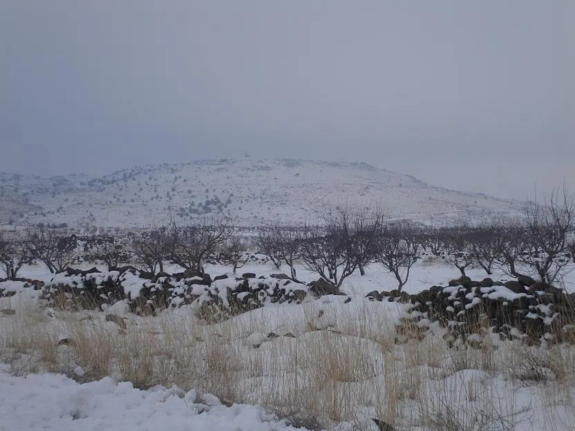
Tell Qeni · Photo: KFZI310 at English Wikipedia · Public domain · Wikimedia Commons · Recorded 2007
Jabal al-Druze
Local name: جبل الدروز
Jabal al-Druze (“mountain of the Druze”), also known as Jabal al-Arab or Jabal Hauran, is an elevated volcanic region in Suwayda Governorate in southern Syria. Most inhabitants are Druze, and there are significant Christian communities. From 1921 to 1936 the area was the Jabal Druze State, an autonomous unit of the French Mandate.
Landscape and geology
The volcanic field is Syria's southernmost and lies on the Hauran–Druze Plateau near the border with Jordan. It consists of 118 basaltic volcanoes active from the lower Pleistocene to the Holocene; lava flows from volcanoes aligned north-west to south-east fill a large plateau depression. The field belongs to the alkaline Harrat al-Sham volcanic field, which extends to Saudi Arabia.
The highest peak is Tell Qeni at 1,803 m, followed by Tell Joualine (1,732 m) and Tell Sleiman (1,703 m); Arabic Wikipedia mentions peaks of more than 1,809 m. Here “tell” refers to a volcanic cone. Snow falls in winter; German Wikipedia describes the mountains as probably the last refuge of the now extinct Syrian wild ass.[1][2][3]
History
According to Arabic Wikipedia the mountain was called Asaldamos in the Greek, Roman and Byzantine periods and Jabal al-Rayyan (“fertile land”) from the early Islamic period to the end of the Abbasids. Safaitic inscriptions were first found in this area. After the battle of Marj Dabiq (dated 1515 by the source), families of the Hamdan settled in Suwayda and Shahba; Druze clans began arriving in 1707 during a civil war in Lebanon.
From the late 17th and early 18th centuries the area was known as “Jabal al-Druze” until, according to Arabic Wikipedia, it was named “Jabal al-Arab” in 1937. Its inhabitants took part in the Great Syrian Revolt against the French Mandate. In the past the name Jabal al-Druze was also used for an area in Mount Lebanon.[1][2][3]
Significance
Suwayda Governorate covers almost the whole of the mountain and is the only governorate in Syria with a Druze majority. In the 1980s the population was 87.6% Druze, 11% Christian (mostly Greek Orthodox) and 2% Sunni Muslim; in 2010 the governorate had about 375,000 inhabitants, 90% Druze, 7% Christian and 3% Sunni. The Christian share has declined through low birth rates and high emigration.
Arabic Wikipedia describes the entire mountain as an archaeological zone with hundreds of sites from the Roman, Byzantine and Nabataean periods, including temples, churches, cisterns, wine presses, monasteries and paved streets. Viticulture is the main crop, alongside apples, pears, wheat and barley.[1][3][4]
Timeline
Documented condition
Current condition not documented
Visiting
Getting here
No service of this category is documented for this governorate. That does not mean none exists.
Nearby medical services
Straight-line distance from this place. Data: OpenStreetMap, as of 2026-10-30. Operating status not verified – call before going.
- Zaid Al Sharity HospitalHospital · 15 kmDirections
- Blood BankHospital · 15 kmDirections
- Al Mazra'a HospitalHospital · 16 kmDirections
- Al mazraa hospitalHospital · 16 kmDirections
- Al 'Enaia Al-Khassa HospitalHospital · 16 kmDirections
- Al Salam HospitalHospital · 17 kmDirections
Sources (17)
- Wikipedia (en): Jabal al-Druze rev. 1382260042 · CC BY-SA 4.0 · 2026-10-30
- Wikipedia (de): Dschabal ad-Duruz rev. 252983621 · CC BY-SA 4.0 · 2026-10-30
- Wikipedia (ar): جبل حوران rev. 76792568 · CC BY-SA 4.0 · 2026-10-30
- Wikidata: Q1262056 (Jabal al-Druze) · CC0 1.0 · 2026-10-30
- Wikipedia (el) · CC BY-SA 4.0 · 2026-10-30
- Wikipedia (es) · CC BY-SA 4.0 · 2026-10-30
- Wikipedia (fr) · CC BY-SA 4.0 · 2026-10-30
- Wikipedia (id) · CC BY-SA 4.0 · 2026-10-30
- Wikipedia (it) · CC BY-SA 4.0 · 2026-10-30
- Wikipedia (ja) · CC BY-SA 4.0 · 2026-10-30
- Wikipedia (nl) · CC BY-SA 4.0 · 2026-10-30
- Wikipedia (pt) · CC BY-SA 4.0 · 2026-10-30
- Wikipedia (ru) · CC BY-SA 4.0 · 2026-10-30
- Wikipedia (sv) · CC BY-SA 4.0 · 2026-10-30
- Wikipedia (tr) · CC BY-SA 4.0 · 2026-10-30
- Wikipedia (ur) · CC BY-SA 4.0 · 2026-10-30
- OpenStreetMap · ODbL · 2026-10-30
Höhenangaben: Tell Qeni 1803 m (en/de), en-Geologie „1800 m hoher Jabal al-Druze“, ar „mehr als 1809 m“. Christliche Gemeinde: de „klein“, en/ar „bedeutend/groß“. Mardsch Dabiq ist in ar mit 1515 datiert (Datum nur zugeschrieben, nicht korrigiert). Datum der Beteiligung am Großen Syrischen Aufstand nennt die Quelle nicht. Die Namensherleitung „Dschabal al-Arab“ über Stammesbündnisse (ar) nicht übernommen, da unbelegt. Relation partOf Q8539961 aus Wikidata P361; Label „Harrat asch-Scham“ aus den Texten erschlossen (Wikidata-Label nicht im Pack). Ereignisse nach 2011 sind in den Quellen nicht dargestellt.