
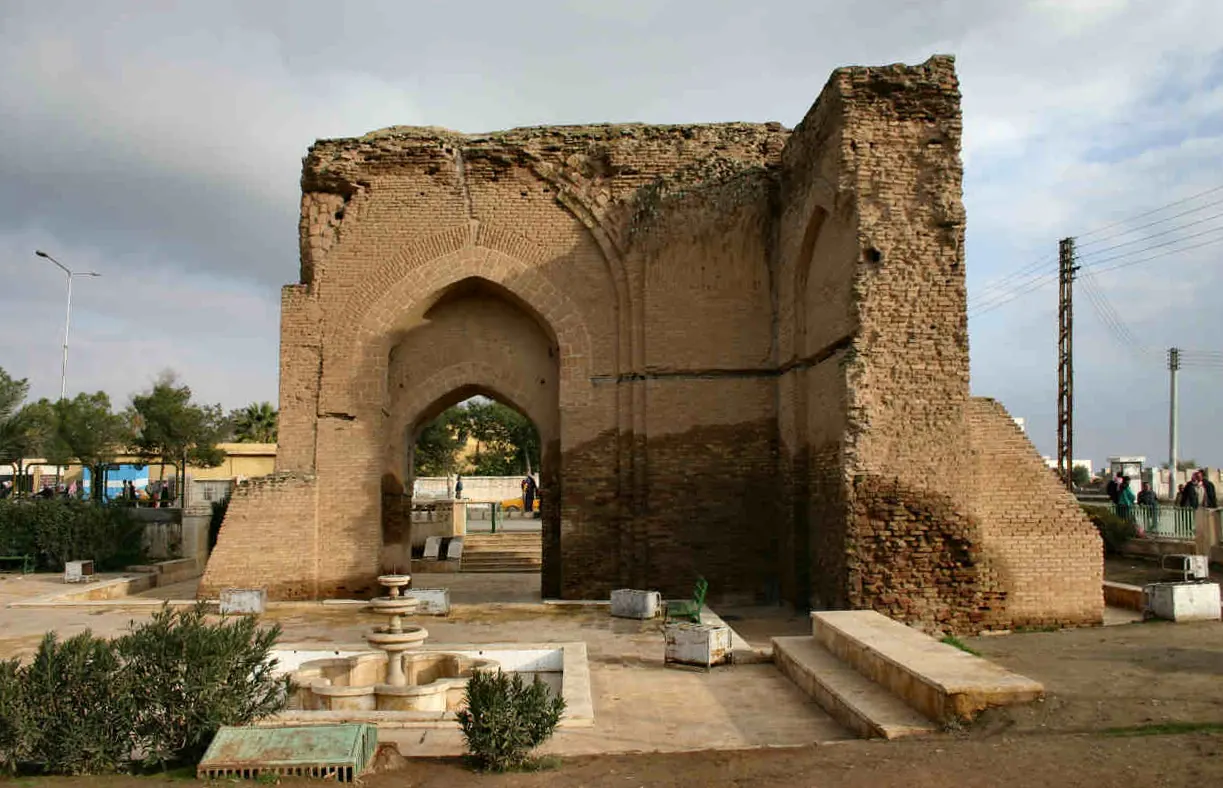
The Abbasid "Baghdad Gate" (8th century) in Ar-Raqqah (Syria) · Photo: http://en.wikipedia.org/wiki/Image:ArRaqqahBadBaghdad.jpg · CC BY-SA 3.0 · Wikimedia Commons
City walls of al-Rafiqah and Baghdad Gate
Local name: سور الرقة وباب بغداد
The walls of al-Rafiqah enclosed the Abbasid garrison city begun in 772 next to old Raqqa on the Euphrates; their horseshoe plan follows the model of Baghdad. A large part of the wall with its round towers survives, partly restored. The Baghdad Gate at the south-east corner is a later structure, probably of the 12th century.
History
According to the English Wikipedia, the Abbasid caliph al-Mansur decided in 770–1 to build a new garrison city west of Raqqa against Byzantium; construction began in 772 under the supervision of his son al-Mahdi and continued at least until 774–5. The German Wikipedia dates the wall to 771–775. According to al-Tabari, al-Rafiqah (“the companion”) followed the plan of Baghdad, but it was smaller, more heavily fortified and horseshoe-shaped rather than round.
From 796 Harun al-Rashid resided at Raqqa/al-Rafiqah, which was effectively the capital of the Abbasid Caliphate until 808 (English Wikipedia: 809); according to the German Wikipedia he added an outer wall between 796 and 806. Al-Sarakhsi, visiting in 884–5, found parts of the walls in ruins. After periods of prosperity under the Zengids and Ayyubids the Mongols destroyed the city (UNESCO: 1258). From 1864/1865 an Ottoman garrison post was established in the south-east corner of the Abbasid enclosure; the first settlers built with bricks from the old enclosure.[1][2][3][4]
Architecture
The main wall was 6.2 metres thick, of mud brick on a stone foundation with a cladding of fired brick. It originally had 132 towers, spaced 25–28 metres apart according to the German Wikipedia and about 35 metres according to UNESCO's description. Its length is given as 4,580 metres (English Wikipedia), 4.5 km (German) or 5 km (UNESCO); it enclosed an area of 1,302 by 1,400 metres whose straight southern side ran parallel to the Euphrates. In front lay a 4.5-metre outer wall and a 15.9-metre moat. The north gate, probably the Harran Gate, is the earliest surviving Abbasid city gate; iron door posts were found there.
The Baghdad Gate stands detached outside the south-eastern bastion. K. A. C. Creswell's date of 772 was refuted in 1978 by John Warren, who argued for the 10th/11th century; Robert Hillenbrand (1985) thinks the second half of the 12th century likely, the English Wikipedia gives the late 11th or 12th century. The 12-by-8-metre building, a central room with flat keel arches, follows Iranian architecture.[1][2][4]
Use and significance
Al-Rafiqah was the largest and most important Abbasid fortification on the Byzantine frontier and the only one to survive. As nothing of Baghdad's Round City remains, the wall is the only surviving comparable example; UNESCO calls it the only known preserved horseshoe-shaped enclosure of the early Abbasid period. The UNESCO Tentative List text sees the line of walls as linking the scattered monuments of Raqqa-Rafiqa, such as the Great Mosque and Qasr al-Banat.[1][2][4]
Timeline
- 772–775
Al-Rafiqah and its wall built under al-Mahdi (German Wikipedia: 771–775; al-Mansur's decision 770–1 per English Wikipedia).[1][2][3][4]
- 796–808/809
Raqqa/al-Rafiqah residence of Harun al-Rashid; outer wall added 796–806 (German Wikipedia).[1][2][3][4]
- 884–5
Al-Sarakhsi describes parts of the walls as ruined.[1]
- 2nd half 12th c.?
Probable date of the Baghdad Gate according to Hillenbrand (Warren: 10th/11th c.; English Wikipedia: late 11th or 12th c.).[1][2]
- 1258
Raqqa and Rafiqa devastated by the Mongols (UNESCO; English Wikipedia: invasions of the 1260s).[1][3][4]
- 1864/1865
Ottoman garrison post in the south-east corner of the enclosure; start of the modern town.[1][2]
- 1970s/1980s
Outer wall and moat bulldozed for new construction.[1]
Gallery
Documented condition
Current condition not documented · as of 2026
According to the English Wikipedia (October 2026) about 2,660 metres of the main wall still stand; the outer wall and moat were bulldozed in the 1970s or 1980s. The German Wikipedia gives about three kilometres in the east and north, restored to a height of at least 5 metres, and 74 surviving towers; UNESCO speaks of about two thirds. The south and east sides of the Baghdad Gate are partly preserved. The sources say nothing about damage to the walls in the civil war, including the 2017 battle for Raqqa.[1][2][4]
Visiting
Getting here
Documented ride, stay and transport services in Raqqa:
Nearby medical services
Straight-line distance from this place. Data: OpenStreetMap, as of 2026-10-30. Operating status not verified – call before going.
- Obstetrics HospitalHospital · 1.4 kmDirections
- National HospitalHospital · 1.7 kmDirections
- HospitalHospital · 1.8 kmDirections
- Alteb Alhadeth HospitalHospital · 1.9 kmDirections
- Al furatrHospital · 2.8 kmDirections
- HospitalHospital · 21 kmDirections
Sources (5)
- Wikipedia (en): Raqqa rev. 1381455915 · CC BY-SA 4.0 · 2026-10-30
- Wikipedia (de): Ar-Raqqa rev. 268736036 · CC BY-SA 4.0 · 2026-10-30
- Wikipedia (ar): الرقة rev. 76511865 · CC BY-SA 4.0 · 2026-10-30
- UNESCO World Heritage Centre: Tentative List entry 1302 (Raqqa – Rafiqa) · 2026-10-30
- OpenStreetMap: City walls of Rafiqa (ways 492671192, 492671181, 492671183, 492671189, 492671185), Baghdad Gate (way 492671161) · ODbL · 2026-10-30
Kein eigenes Wikidata-Objekt; Identität über OSM (Quelle 5): 'osm' enthält die fünf historic=citywalls-Ways; das Bagdadtor ist separat als way/492671161 (historic=castle, name 'باب بغداد') erfasst und könnte ergänzt werden; weitere OSM-Objekte (Qasr al-Banat way/457526661, Burj ar-Raqqa node/571225316, 'Raqqa wall gate'-Nodes) gehören nicht zur Mauer im engeren Sinn. Keine Koordinaten im Datensatz; falls nötig nur aus der OSM-Liste. Namen: kein eigenes Lemma; de/en/ar beschreibend aus den Artikeltexten und OSM-Namen gebildet. Widersprüche: (1) Baubeginn – en Entscheidung 770/771, Baubeginn 772, Bau bis mindestens 774/775; de 772 bzw. 771–775 (Stadtbild-Abschnitt); ar und UNESCO 772 unter al-Mansur. (2) Länge – en 4580 m, de 4,5 km, UNESCO 5 km. (3) Erhalten – en 2660 m, de ca. 3 km restauriert, UNESCO zwei Drittel; Türme 132 (alle), davon 74 erhalten (de). (4) Turmabstand – de 25–28 m, UNESCO ca. 35 m. (5) Hauptstadtzeit – en 796–809, de/ar 796–808, UNESCO 'über 13 Jahre'. (6) Mongolen – UNESCO/ar 1258, de nach 1258, en 1260er. (7) Nordtor – en ausgegraben und teilrekonstruiert in den 1990ern, de ausgegraben in den 1980ern; de nennt Verkauf des Eisens im 10. Jh. an die Qarmaten, en eine andere Überlieferung zu einem Eisentor (Amorion–Samarra–Raqqa–Aleppo) – beide nicht übernommen. (8) Bagdadtor – Creswell 772, Warren 10./11. Jh., Hillenbrand 2. Hälfte 12. Jh., en spätes 11./12. Jh.; UNESCO nennt es nur 'porte dite de Bagdad' im Südosten. (9) Osmanischer Posten – en 1864, de 1865. (10) Ursprüngliche Mauerhöhe: de ca. 18 m (geschätzt), en 18 m nur für das Nordtor – nicht übernommen. Zustand: keine datierte Zustandsangabe; keine Quelle zu Schäden 2013–2017. UNESCO-Tentativlisteneintrag 1302 (Titel nicht im Paket; Name der Quelle beschreibend); Jahr der Eintragung nicht im Paket. Keine Relation gesetzt (Q-ID von Raqqa nicht im Paket).