
Photo: author unknown · CC BY-SA 2.5 · Wikimedia Commons
Church of Saint Simeon Stylites
Local name: دير سمعان
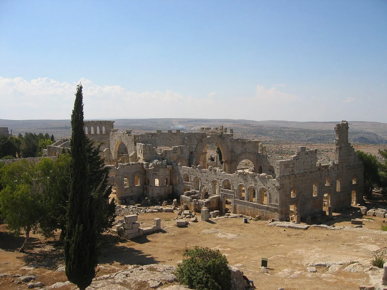
Qal'at Sim'an is the ruin of an early Byzantine pilgrimage and monastic complex on a limestone plateau northwest of Aleppo. It was built where the pillar saint Simeon Stylites lived and died in 459; its cross-shaped church of four basilicas around an octagon enclosing the saint's column remained the largest church in the Christian world until Hagia Sophia was completed in 537. Since 2011 it has formed part of the serial World Heritage property “Ancient Villages of Northern Syria”, listed as in danger since 2013.
History
English Wikipedia gives 390 as Simeon's year of birth; Arabic Wikipedia gives 389 and names the village of Sisan. At sixteen he entered a monastery but was judged too extreme in his asceticism for communal life. In 412 he joined the monastery of Telanissos, later withdrew to the hill above it and finally lived on a small platform atop a column that was raised over time from about 3 to 18 metres. He preached from there twice a day and was consulted by eastern emperors. After his death in 459, a dispute over his remains was settled in favour of Antioch.
A few decades later, with imperial support, the great church rose over the column. Dates differ: German Wikipedia gives 476 to 490 and links the processional roads to Emperor Zeno (r. 474–491); English Wikipedia names 473 as the start and 490 as completion. According to English Wikipedia, the monastery passed to the Miaphysites in 638.
After the Arab conquests the Byzantines fortified the church, and in the 10th century the complex was turned into a citadel with a wall and 13 towers, the origin given for the name “Fortress of Simeon”. The Hamdanid commander Qarghuya sacked it and killed its monks; English Wikipedia dates this once to 985 and once to 986. The site then lay abandoned for a long time.[1][2][3]
Architecture
The church was conceived and executed as a single project within a short time. Four three-aisled basilicas, each 24 metres wide, extend in the shape of a cross from a central octagon 28 metres across, with the column at its centre; the building measures 100 metres east to west and 88 metres north to south. The east basilica is larger than the others and alone has three apses, as it hosted the liturgy. English Wikipedia states that a dome crowned the octagon and apparently survived into the 19th century.
The walled complex also held two smaller churches, a monastery with chapel south of the east basilica, pilgrim hostels and a baptistery on the Via Sacra. Built shortly after the main church, the baptistery is an octagon on a square base that at one time had a wooden conical or domed roof; a stepped passage leads down from its eastern apsidiole. The basilica of Qalb Loze, completed around 470, is regarded as the model for the architecture and ornament; its style was taken up at Deir Turmanin and Deir Seta, among others.[1][2]
Use and significance
Even in his lifetime believers sought Simeon's advice and guidance; after his death the site remained a place of pilgrimage. The complex was laid out for these crowds: pilgrims entered from the south through an arch at the foot of the hill and passed the baptistery and hostels on the way to the south portal of the main church. Below, on the plain, lay the pilgrim town of Deir Seman, linked to Antioch by processional roads.
From the 10th century the complex served as a fortified site. For centuries pilgrims chipped pieces off the column as relics; substantial parts of the shaft were last visible in the 17th century, and only a block about two metres high now remains.[1][2]
Notable features
German Wikipedia gives 4,800 square metres for the church and 12,000 square metres for the whole complex; English Wikipedia speaks of more than 5,000 square metres. Excavations led by Jean-Pierre Sodini between 1980 and 2004 uncovered polished black-and-red Kura-Araxes pottery in the western part of the martyrium, a culture that arose in the southern Caucasus between 3500 and 3300 BC.
UNESCO values the villages of the Limestone Massif as testimony to rural life in late Antiquity and to the spread of Christianity in village communities.[1][2][4]
Timeline
- 459
Death of Simeon Stylites; his remains are taken to Antioch.[1][2]
- 476–490
Construction of the church complex (another account gives 473 as the start), completed 490.[1][2]
- 638
The monastery passes to the Miaphysites.[1]
- 985/986
Sack by the Hamdanid commander Qarghuya; the sources give both 985 and 986.[1]
- 2011
Inscribed as part of the World Heritage property “Ancient Villages of Northern Syria”.[1][4]
- 2013
Placed on the List of World Heritage in Danger.[4]
- May 2016
An air strike damages the remains of the column and the ruins.[1][4]
Gallery
Documented condition
Partly damaged · as of 2016 Historically documented
At inscription in 2011 UNESCO stressed the villages' very high degree of authenticity after a thousand years without occupation; in 2013 the property was placed on the List of World Heritage in Danger. In the Syrian civil war the site suffered from fighting, illegal digging and stone removal; on 28 May 2015 Kurdish YPG/YPJ forces captured it before losing it to anti-government factions. In May 2016 a Russian air strike damaged the remains of the column and the surrounding ruins; on 17 May 2016 UNESCO's Director-General deplored severe damage. By 8 February 2020 Turkish Land Forces occupied the hilltop near the site.
Arabic Wikipedia reports rehabilitation and restoration after a 14-year closure, dated September 2026; the other sources do not confirm this.[1][3][4]
Visiting
Getting here
Documented ride, stay and transport services in Aleppo:
Nearby medical services
Straight-line distance from this place. Data: OpenStreetMap, as of 2026-10-30. Operating status not verified – call before going.
- Al-Kinana HospitalHospital · 6.5 kmDirections
- AlaimanHospital · 12 kmDirections
- AlakaahHospital · 14 kmDirections
- Atmeh Burn-Unit HospitalHospital · 15 kmDirections
- مشفى الدانا حريتانHospital · 15 kmDirections
- Hand and handHospital · 15 kmDirections
Sources (19)
- Wikipedia (en): Church of Saint Simeon Stylites rev. 1370539844 · CC BY-SA 4.0 · 2026-10-30
- Wikipedia (de): Qalʿat Simʿan rev. 269492675 · CC BY-SA 4.0 · 2026-10-30
- Wikipedia (ar): دير سمعان (سوريا) rev. 76936199 · CC BY-SA 4.0 · 2026-10-30
- UNESCO World Heritage Centre: Ancient Villages of Northern Syria · 2026-10-30
- Wikidata · CC0 · 2026-10-30
- Wikipedia (es) · CC BY-SA 4.0 · 2026-10-30
- Wikipedia (fa) · CC BY-SA 4.0 · 2026-10-30
- Wikipedia (fr) · CC BY-SA 4.0 · 2026-10-30
- Wikipedia (id) · CC BY-SA 4.0 · 2026-10-30
- Wikipedia (it) · CC BY-SA 4.0 · 2026-10-30
- Wikipedia (ja) · CC BY-SA 4.0 · 2026-10-30
- Wikipedia (ko) · CC BY-SA 4.0 · 2026-10-30
- Wikipedia (nl) · CC BY-SA 4.0 · 2026-10-30
- Wikipedia (pt) · CC BY-SA 4.0 · 2026-10-30
- Wikipedia (ru) · CC BY-SA 4.0 · 2026-10-30
- Wikipedia (sv) · CC BY-SA 4.0 · 2026-10-30
- Wikipedia (ur) · CC BY-SA 4.0 · 2026-10-30
- Wikipedia (zh) · CC BY-SA 4.0 · 2026-10-30
- OpenStreetMap · ODbL · 2026-10-30
Quellenkonflikte: Geburtsjahr Symeons 390 (en) vs. 389 (ar); Säulenhöhe 18 m (en, de) vs. 40 Ellen/ca. 15 m (ar); Baubeginn 473 (en) vs. 476 (de); Fläche über 5000 m² (en) vs. Kirche 4800 m²/Komplex 12.000 m² (de); Plünderung 985 vs. 986 innerhalb des en-Artikels; Entfernung von Aleppo ca. 30 km (en) vs. 35 km (de, nicht im Text verwendet). en-Artikel ist zur Klostergründung von Telanissos widersprüchlich (Mitte 5. Jh. vs. Beitritt Symeons 412). Nicht übernommen: Angaben der ar-Wikipedia zu Umar ibn Abd al-Aziz (bezieht sich vermutlich auf ein anderes Deir Simʿan) und zur Festung unter Saladin. Die ar-Angabe einer Restaurierung/Wiedereröffnung im September 2026 ist unbelegt und von keiner weiteren Quelle bestätigt; Zustandsangaben der UNESCO-SOC-Berichte (2013–2026) wurden nicht eingesehen, da nur die Liste der Berichtsjahre im Paket enthalten ist.