
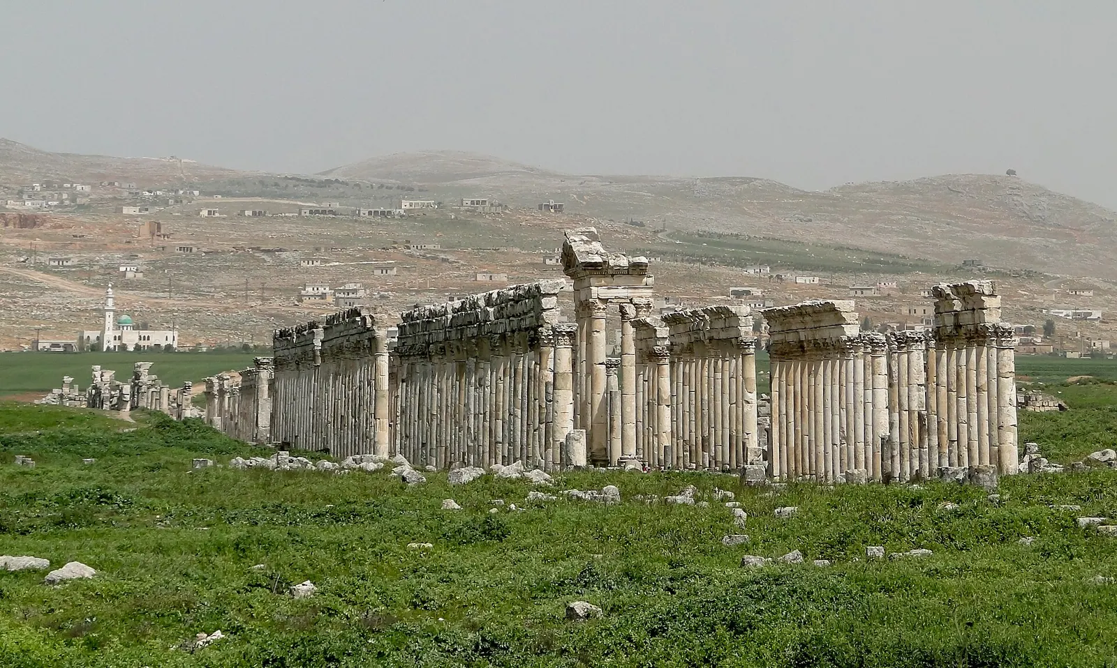
View of Apamea, Syria · Photo: Bernard Gagnon · CC BY-SA 3.0 · Wikimedia Commons · Recorded 2010
Apamea
Local name: أفامية
Apamea is an ancient city on a plateau above the Orontes and the Ghab valley, on the edge of modern Qalaat al-Madiq, about 55 kilometres northwest of Hama. Established as a city by Seleucus I around 300 BC, it later became the capital of the Roman province of Syria Secunda. It is best known for its great colonnaded street, and it is on Syria's UNESCO World Heritage Tentative List.
History
Accounts of the site's beginnings differ: German Wikipedia gives its original name as Pharnakes and, after Alexander, briefly Pella; English Wikipedia follows an interpretation of a mosaic discovered in 2011 according to which Pella was founded as a Macedonian military settlement in autumn 320 BC. Around 300 BC (UNESCO: 301 BC) Seleucus I Nicator fortified it as a city and named it after his wife Apama. Apamea belonged to the Syrian tetrapolis and was a Seleucid military base and mint.
Rome took control in 64 BC (German Wikipedia: 63 BC). A census of AD 6/7 counted 117,000 citizens or free men; the total population this implies is disputed. The earthquake of 115 destroyed much of the city, which was rebuilt over the 2nd century. In the early 5th century Apamea became capital of Syria Secunda. According to German Wikipedia it surrendered to Khosrow I without a fight in 540; in 613 it fell to the Sasanians for several years.
After the Muslim conquest in the 7th century the city was sacked according to German Wikipedia and partially resettled according to English Wikipedia; the fortress remained inhabited. Crusaders under Tancred took it around 1106, and Nur al-Din recaptured it in 1149. Earthquakes in the 12th century destroyed the city; the sources give 1152 (English) and 1157–1170 (Arabic).[1][2][3][4]
Site
The sources give the area of the ruins as more than 200 or 250 hectares, enclosed by a wall about seven kilometres long. The colonnaded street (cardo maximus) ran from the north to the south gate; its length is given as almost 1,600 m (de), 1,774 m (ar), 1,800 m (UNESCO) and nearly 2 km (en), and its width including porticoes as 37.5 to almost 40 metres. According to UNESCO its columns, some with spiral fluting, were built between Trajan and Septimius Severus; the street was remodelled under Justinian.
Along it lay baths, the agora, a nymphaeum, a tycheion and churches, including a cathedral in the form of a tetraconch. The theatre, more than 135 metres in diameter, is considered the largest in Syria; English Wikipedia estimates over 20,000 seats. A synagogue with a mosaic floor of about 391 was replaced by a church in the 5th century. The citadel of Qalaat al-Madiq stands on the old acropolis.[1][2][3][4]
Historical use and significance
In late antiquity Apamea was home to a school of philosophy and a bishop's see. Belgian excavations under Franz Cumont (1930–1938, 1947, 1953) and from 1965 under Jean-Charles Balty brought many finds to Brussels, among them the Great Hunting Mosaic of about 415–420 and a reconstructed section of the colonnade. According to Arabic Wikipedia, the 16th-century Ottoman khan below the citadel has housed a mosaic museum since 1987.[1][2][3]
Timeline
Gallery
Documented condition
Partly damaged · as of 2017
According to German Wikipedia, the colonnade came under artillery fire on 15 March 2012, and aerial images from spring 2013 showed many large looting pits. Arabic Wikipedia reports thefts from the museum in 2011–2012, bullet holes in columns and partial demolition of walls. English Wikipedia cites satellite images from April 2017 showing hundreds of holes dug by looters.[1][2][3]
Visiting
Getting here
Documented ride, stay and transport services in Hama:
Nearby medical services
Straight-line distance from this place. Data: OpenStreetMap, as of 2026-10-30. Operating status not verified – call before going.
- HospitalHospital · 19 kmDirections
- مشفى دير شميلHospital · 22 kmDirections
- مشفى الايمان التخصصيHospital · 22 kmDirections
- الايمانHospital · 22 kmDirections
- مستوصف خان شيخونHospital · 23 kmDirections
- مشفى المحبة محردةHospital · 23 kmDirections
Sources (23)
- Wikipedia (en): Apamea, Syria rev. 1378468325 · CC BY-SA 4.0 · 2026-10-30
- Wikipedia (de): Apameia am Orontes rev. 265513031 · CC BY-SA 4.0 · 2026-10-30
- Wikipedia (ar): أفامية rev. 74590118 · CC BY-SA 4.0 · 2026-10-30
- UNESCO World Heritage Centre, Tentative List: Apamée · 2026-10-30
- Wikidata · CC0 · 2026-10-30
- Wikipedia (el) · CC BY-SA 4.0 · 2026-10-30
- Wikipedia (es) · CC BY-SA 4.0 · 2026-10-30
- Wikipedia (fa) · CC BY-SA 4.0 · 2026-10-30
- Wikipedia (fr) · CC BY-SA 4.0 · 2026-10-30
- Wikipedia (id) · CC BY-SA 4.0 · 2026-10-30
- Wikipedia (it) · CC BY-SA 4.0 · 2026-10-30
- Wikipedia (ja) · CC BY-SA 4.0 · 2026-10-30
- Wikipedia (ko) · CC BY-SA 4.0 · 2026-10-30
- Wikipedia (nl) · CC BY-SA 4.0 · 2026-10-30
- Wikipedia (pl) · CC BY-SA 4.0 · 2026-10-30
- Wikipedia (pt) · CC BY-SA 4.0 · 2026-10-30
- Wikipedia (ru) · CC BY-SA 4.0 · 2026-10-30
- Wikipedia (sv) · CC BY-SA 4.0 · 2026-10-30
- Wikipedia (tr) · CC BY-SA 4.0 · 2026-10-30
- Wikipedia (ur) · CC BY-SA 4.0 · 2026-10-30
- Wikipedia (zh) · CC BY-SA 4.0 · 2026-10-30
- UNESCO World Heritage Centre · © UNESCO (link only) · 2026-10-30
- OpenStreetMap · ODbL · 2026-10-30
Tentativliste: Eintrag tentative/1297 belegt, Aufnahmejahr im Paket nicht genannt (daher ohne Jahr). Konflikte: Länge der Säulenstraße knapp 1600 m (de) / 1774 m (ar) / 1800 m (UNESCO) / fast 2 km (en); Fläche über 200 ha (de) vs. 250 ha (UNESCO); Theaterdurchmesser 139 m (de) vs. über 135 m (UNESCO); Gründung 300 v. Chr. (en) vs. 301 v. Chr. (UNESCO), Vorgängername Pharnakes (de) vs. Pella 320 v. Chr. (en, nach Olszewski/Saad); römisch 64 (en, ar) vs. 63 v. Chr. (de); Sasaniden 613 (en, de) vs. 612 (ar); Folgen der muslimischen Eroberung (Plünderung de vs. Teilwiederbesiedlung en); Erdbeben 1152 (en) vs. 1157–1170 (ar). Nicht übernommen: ar-Angabe zu einem hethitischen Königreich im 9. Jh. v. Chr. und zur Münzprägung „bis Claudius 41 v. Chr.“ (widersprüchlich). Zustand: keine institutionelle Schadensbewertung im Paket; Status „partly-damaged“ gewählt, de spricht von „starker Zerstörung“ der Fundstelle durch Raubgrabungen – ggf. auf „heavily-damaged“ anheben.