
Photo: ISS Expedition 24 crew · Public domain · Wikimedia Commons · Recorded 2010
Al-Safa
Local name: تلول الصفا
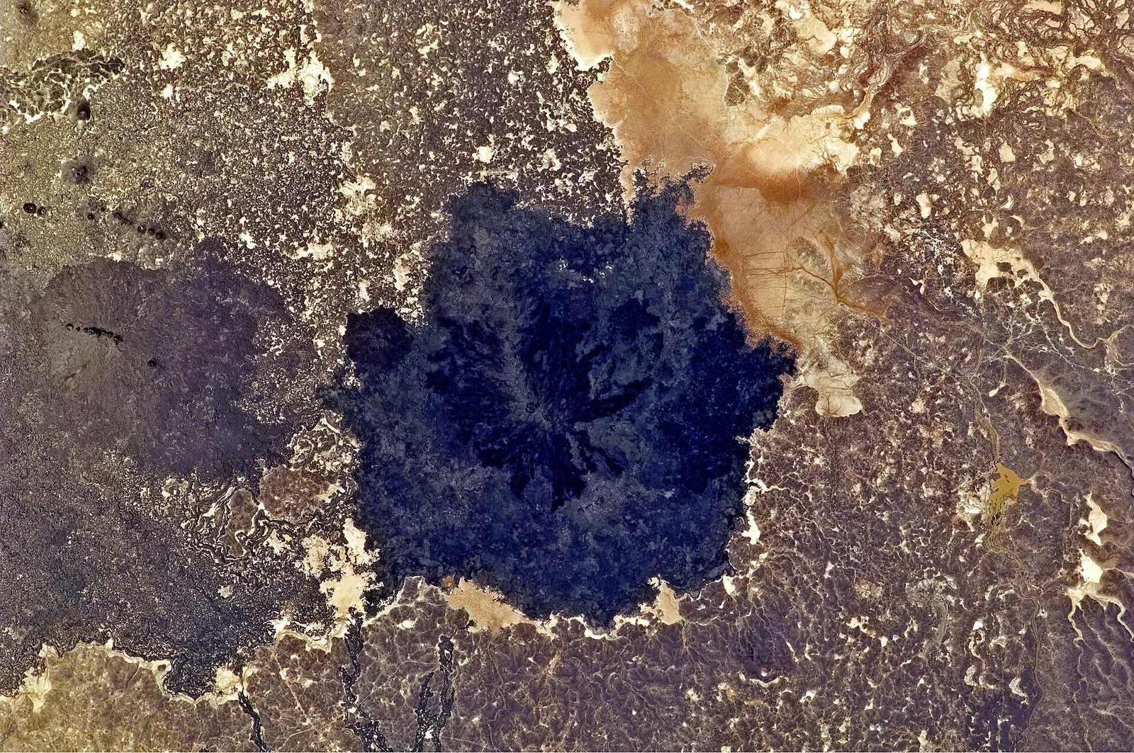
Al-Safa (Arabic Tulul al-Safa, “the al-Safa hills”) is a basaltic volcanic field in southern Syria, north-east of Jabal al-Druze and about 95 km south-east of Damascus. The area of about 220 km² is extremely short of water and gave its name to the Safaitic script.
Landscape and geology
The field contains at least 38 cinder cones and forms part of the northern section of the alkaline Harrat al-Sham volcanic field, which according to German Wikipedia covers about 50,000 km² across Syria, Jordan, Israel/Palestine and Saudi Arabia. Arabic Wikipedia describes a roughly circular area 16 to 19 km across, bordered by the Syrian Desert to the north, the Hamad to the south and the al-Kura' area to the south-west.
Several vents were active during the Holocene. A boiling lava lake was observed in the middle of the 19th century – Arabic Wikipedia gives 1850 – and particularly dark areas in the centre are thought to mark this latest activity. A study published in 2002 identified Tulul al-Safa as the youngest of 13 lava flows in southern Syria, northern Palestine and eastern Lebanon. The highest cones include Tell el-Aqzass (889 m), Tell ed-Ders (878 m) and Jabal Rgheli (874 m).[1][2][3]
History
In 1857 inscriptions in a previously unknown script were discovered here; the script was named Safaitic after the area, although it is now attested elsewhere too. Arabic Wikipedia counts more than 2,000 known Safaitic inscriptions and, following some historians, attributes them to groups of the Lakhmids. Nearby are sites from the 4th millennium BCE, among them Khirbet al-Umbashi and Khirbet al-Habbariyah, and the site of Jabal Sis.
The Druze used the area as a refuge in times of war. During the civil war al-Safa became the last pocket of ISIL in Suwayda and Rif Dimashq governorates; government forces took control of it on 17 November 2018.[1][3]
Significance
The area lies entirely within Suwayda Governorate, whose border follows its edge. It is sparsely populated; according to English Wikipedia only roaming Bedouin and occasional archaeologists visit it. Arabic Wikipedia mentions plans to designate Tulul al-Safa a geopark as a natural extension of the Lajat reserve.[1][2][3]
Timeline
- c. 1850
A boiling lava lake is observed (en: mid-19th century, ar: 1850).[1][3]
- 1857
Discovery of inscriptions in the script later called Safaitic.[1]
- 2002
Study identifies Tulul al-Safa as the youngest of 13 regional lava flows.[3]
- 17 Nov 2018
Government forces take control of the last ISIL pocket in Suwayda on 17 November.[1]
Gallery
Documented condition
Current condition not documented
Visiting
Getting here
Documented ride, stay and transport services in Rif Dimashq:
Nearby medical services
Straight-line distance from this place. Data: OpenStreetMap, as of 2026-10-30. Operating status not verified – call before going.
No hospital within 30 km in the data.
Sources (6)
- Wikipedia (en): Al-Safa (Syria) rev. 1361638526 · CC BY-SA 4.0 · 2026-10-30
- Wikipedia (de): Es-Safa rev. 271101414 · CC BY-SA 4.0 · 2026-10-30
- Wikipedia (ar): تلول الصفا rev. 76481053 · CC BY-SA 4.0 · 2026-10-30
- Wikidata · CC0 · 2026-10-30
- Wikipedia (es) · CC BY-SA 4.0 · 2026-10-30
- Wikipedia (fr) · CC BY-SA 4.0 · 2026-10-30
Höhenkonflikt: ar nennt für das Gebiet 979 m, der höchste Kegel in der en-Liste hat 889 m – 979 m nicht übernommen. Lavasee: en „Mitte des 19. Jh.“, ar 1850 (in der Zeitleiste als ca.-Datum). Ausdehnung der Harrat asch-Scham: de/ar ~50.000 km², Länderliste je nach Quelle (en: Syrien–Jordanien–Saudi-Arabien; de: Israel, Syrien, Jordanien, Saudi-Arabien; ar: Saudi-Arabien, Palästina, Jordanien, Syrien) – zusammengefasst. Die Zuschreibung der safaitischen Inschriften an Lachmiden im 6. Jh. v. Chr. (ar, „einige Historiker“) ist fachlich fraglich; nur als zugeschriebene Ansicht ohne Datum übernommen. Relation partOf Q8539961 aus Wikidata P361; Label aus den Texten erschlossen. Geopark-Pläne undatiert.